
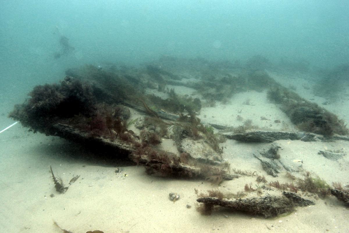
Large numbers of shipwrecks, unidentified anomalies, and debris have built up on the seabed over the twelve millenia of maritime activity in UK waters. Only a fraction of this submerged cultural resource is currently recorded.
The England’s Shipping project was undertaken by Wessex Archaeology to research ways of mapping shipping movements recorded in historical archives. The data gathered was mapped using a Geographic Information System (GIS) and required the development of a methodology for representing historical data spatially. The project was funded by that part of the Aggregate Levy Sustainability Fund (ALSF) distributed by English Heritage.
Project background
During the preparation of an Environmental Impact Assessment (EIA), several data sources are consulted to gauge the quantity and character of known archaeological remains within an area. Sources consulted during the preparation of EIAs dealing with the marine and coastal environment include:
-
The National Record of the Historic Environment (NRHE);
-
Local Sites and Monuments Records (SMRs), Historic Environment Records (HERs);
-
The Receiver of Wreck at the Maritime and Coastguard Agency;
-
Local records offices, museums and libraries.
While this data forms the core of an assessment of the potential maritime archaeology of an area it is generally biased towards wrecks from the mid-eighteenth century onwards. This bias primarily stems from the emergence of official records of shipping losses from the 1730s onwards and from the greater visibility to hydrographic survey techniques of metal vessels from the later 19th and 20th centuries.
Archaeological investigations and hydrographic surveys over recent decades have allowed the identification of exposed ship structure at many locations around the coast of England. Amateur divers often discover wreck sites by chance or find them when investigating snagged fishing gear. Recent historical wrecks are easier to detect than those dating to the prehistoric or medieval periods. The increasing use of metallic elements rather than wood and other organic materials facilitates the identification of more recent sites through remote sensing. Thus the record as a whole reflects only a fraction of the maritime activity that has taken place in UK waters throughout history.
Before the 18th century, evidence for maritime activity is restricted to rare and often fragmentary archaeological data and, from the early medieval period at least, a wide range of disparate primary and secondary sources. Access to many of these sources is often difficult and time-consuming which generally prevents any significant study of such sources in formulating baselines for EIAs.
The England’s Shipping project proposed to temper these biases and facilitate a fuller appreciation of maritime archaeological potential through the development of a digital atlas of historic shipping patterns. Data from primary and secondary documentary sources about pre-1730 shipping was used to map the intensity of traffic along particular routes and at particular locations, including ports, anchorages and battle sites. It was proposed that using such data alongside archaeological evidence for known wreck sites would assist seabed developers, their archaeological advisors and heritage curators with the identification of potential maritime sites and finds within defined areas for the purposes of marine aggregate licence proposals.
Data and source appraisal
During the development of the GIS the initial Study Areas chosen for the project (the south-east coast, the Thames Estuary and the English Channel) were found to be problematic. For example, it was difficult to gather data solely relating to specific areas due to the scarcity of data capable of being mapped. As a result the Study Areas were changed to highlight the capabilities of the database and to maximise the use of the GIS. The most suitable data was identified along the East Coast, including information on vessel traffic journeys, battle and casualty locations recorded in, offshore hazards, anchorages, wreck sites and aggregate extraction areas. The Study Areas were thus reassessed to focus on the Solent and the East Coast of England from Norfolk to the South Kent coast.
Research was carried out to first identify and then appraise as many appropriate primary and secondary sources as possible. The catalogues of Southampton City Library (SCL), the Public Record Office (PRO) and the Caird Library of the National Maritime Museum (NMM) were searched for relevant sources.


The appraisal showed that the quantity and quality of data varied from region to region, particularly in respect of merchant shipping. Virtually no information was available on fishing industries, non-commercial transport and the use of private vessels before the 18th century.
The appraisal of sources proved to be an ongoing process during the project. The types and formats of historical records on maritime activities vary a great deal. During the gathering of data, new data is often identified which requires the project to adapt to contain it.
The primary sources of information on shipping routes identified were Port Books, early Customs records, Board of Trade Shipping Returns, Royal Navy Masters’ Logs, ship's registers and other Logs. Historic charts were also evaluated during the project as sources of information on battle site locations.
In practice, the large amount of information identified during the project could not be dealt with in the time available so it was necessary to limit the number of sources accessed by project staff. Also, difficulties with accessing, reading and translating pre-1730 original sources meant that recording focused upon secondary sources, especially transcriptions of Port Books.
Project aims
England's Shipping is a pioneering project funded by the Aggregate Levy Sustainability Fund, and in this case, administered by English Heritage. It aims to develop ways to make better use of the vast quantities of information that exists in the historical record about the movements and activities of ships in the past.
The project output is principally designed to support seabed developers, their archaeological advisors and heritage curators in assessing maritime archaeological potential on the seabed during the preparation of dredging work proposals. However, English heritage intend to make the information results and search facilities available to the general public through the National Monuments Records search facilities. Although the project is designed to run for two years, the gathering of information relating to England’s Shipping is intended as an ongoing task. The project is currently being structured around a series of case study areas drawn from concentrations in the pattern of dredging activities in English waters.
The project aims agreed with English Heritage are as follows:
-
Map the intensity and other characteristics of pre-1730 shipping in UK waters
-
Collate information about shipping patterns in an accessible format
-
Develop a database which can contain data reflecting the multiple facets of shipping related data
-
Map the data using a GIS format to enable the user to query the data
-
Provide an Outreach schedule to disseminate results
In order to meet ALSF requirements to engage the wider public in the importance of the marine historic environment and in order to facilitate access to the data, it is anticipated that the content of the digital atlas will be made available to users via the NMR.
Database
To enable the collation of and presentation of data gathered from different sources a project database was constructed using Microsoft Access linked to a Geographical Information System (GIS) using ArcView GIS 8.3.
The England’s Shipping database was designed to facilitate the transfer of data to and from the NMR and complies with the Monument Inventory Data Standard (MIDAS) developed by the Forum on Information Standards in Heritage (FISH). The database structure, as well as the user interface, mirrors the Monument-Event-Source philosophy of MIDAS using NRHE word lists to ensure consistent terminology. The database was also constructed with a simple querying interface to enable the user to search the data. A set of guidelines were produced outlining best practice for entering data into the system.
The database is based upon four main forms:
-
Ship movements - including data on the journey, the characteristics of the vessel(s) and associated persons, the cargo types and quantities and any additional data concerning the ship movement;
-
Casualties - including descriptions and co-ordinates for all types of ‘losses’, including wrecks, prizes taken in battle, vessels running aground, fire damage, and scuttling. Although these events did not necessarily lead to the sinking of a vessel they may have led to the deposition of archaeological material on the seabed and were therefore important to record and map;
-
Battles - including data about the states and countries at war, the vessels, fleets and persons involved, and the vessels and human casualties;
-
Sources - including bibliographic information for the sources on which the records were based.
A further form was used specifically for recording the co-ordinates of ports and anchorages. Tables of summary data were also incorporated into the database. Such summary data has typically been compiled by various authors; providing statistics of numbers of voyages undertaken, vessels entering and exiting ports, levy costs, and quantities and types of cargo.
Secondary sources based on primary administrative records and historic narratives often contain numerous extracts from primary records. In order to deal with issues of reliability and quality of research, the England’s Shipping database was designed to record not only the data itself but also the different sources of information from which the datasets were drawn, where to find the source, and whether they were primary or secondary, thereby allowing the user to make a judgement on the quality of data.
During data entry it was also noted that there was high potential for the duplication of records within the database. For example, duplication may occur where the same voyage is referred to by more that one source. To avoid this, a duplicate record query was built into the database to enable individuals to check for duplication as the records were entered.
Geographical Information System (GIS)
A GIS is a computer package capable of assembling, storing, manipulating, and displaying geographically referenced information.

For the purposes of England’s Shipping the use of GIS enabled the data gathered from historic sources to be displayed on a map and for each recorded aspect or ‘attribute’ (type of vessel, date of loss etc) to be organised into different layers of information, which can be interrogated using digital tools to extract specific information. For example, the individual position of a known shipwreck will have many different attributes, all of which are related to its position, such as the date of loss, size, ship type, or cargo carried, each of which can be analysed individually or in combination. In this way it is possible to view the data at many different levels and identify patterns or coincidences that might not otherwise be discernible.
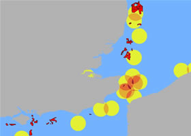
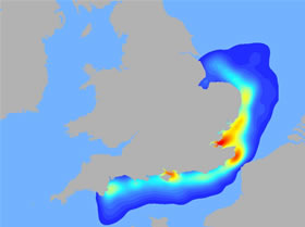
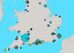
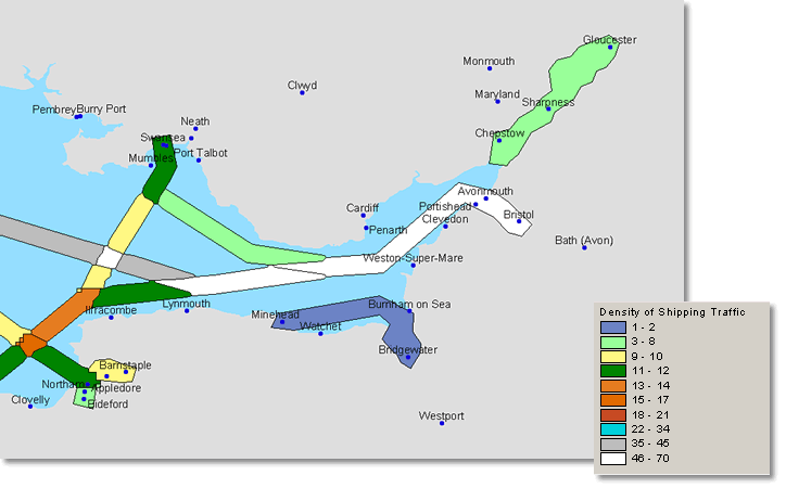
The GIS was intended to display a network of shipping routes to represent shipping traffic over time. In addition to this the point and/or area data relating to battles, anchorages, ports and casualty events at specific locations was also mapped. Such data was used to improve the mapping of data drawn from historical records for which locations had not been specified. The data also facilitated the observation of ‘hotspots’ of archaeological potential for different types of event in the seas around the UK.
Results
The project successfully resulted in the creation of a system which could contain extensive amounts of data recorded from archival sources, and the development of a methodology for representing historical data spatially whilst mitigating against the uncertainty of locating events.
Initial querying of the data showed that the system was working effectively and that trends in the initial dataset could be identified. Three case-study dredging areas were also chosen to test the sample data collated during the project. The analysis of the three areas showed additional data available on battle events, some information on the nature of trade travelling through the area, and the relative importance of local ports during different centuries. Although the data entered in the database would have been initially biased towards the areas for which more information was available, further population of the database would reduce these biases.
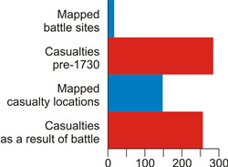
An example of the level of data recorded during the course of the project can be seen below. The number of events mapped is depicted on the left and the graph on the right reflects the type of voyages undertaken by vessels in the area.
 |
 |
These figures demonstrate the success of the project in identifying and recording a substantial amount of data relating to pre-1730 shipping, thus providing a means of reducing the post-18th century bias apparent in the sources currently employed in formulating EIAs.
The project also achieved its objective of providing a basic model for mapping historic shipping routes around the UK and providing a representation of the density of traffic recorded along any particular route. The route network can be used to provide contextual information on known wreck sites. For example, if a wreck is known to have carried wool as a cargo, the attributes relating to that particular cargo, its importance or the trade of relevant historic pots and related shipping routes can be analysed in order to provide a characterisation of that vessel in the wider context of England’s shipping during that period.
The querying of data for traffic density entering and leaving ports provided a better representation of traffic density for the approaches to locations. Although it could not be extended further to sea, a reflection of the size and importance of a port, the nature of trade and its military importance would provide an indication of the likely density of traffic travelling through the area. Further population of the database could improve our ability to quantify and characterise the potential for archaeology on the seabed, based on the importance of ports and the character of voyages between them.
Topics
ALSF
The ALSF uses revenue from the Aggregates Levy to fund research projects targeted at reducing the impact of dredging upon the environment. The ALSF is made available by the Department for Environment, Food & Rural Affairs (DEFRA) and distributed by the governmental advisory bodies English Heritage, English Nature and the Countryside Agency in consultation with local authorities, interest groups and the aggregate industry.
In 2002 £35 million was allocated for an initial two-year pilot scheme, subsequently extended for a further three years. DEFRA carried out a policy review of the ALSF during 2006 to examine the extent to which the ALSF has met its objectives and whether the scheme should continue beyond 2007. The outcome of the review was that it was decided to continue the fund until 2011.
The English Heritage ALSF Programme focuses on the following main areas:
- Developing the capacity to manage aggregate extraction landscapes in the future;
- Delivering to public and professional audiences the full benefits of knowledge gained through past work in advance of aggregates extraction;
- Reducing the physical impacts of current extraction where these lie beyond current planning controls and the normal obligations placed on minerals operators;
- Addressing the effects of old mineral planning permissions;
- Promoting understanding of the conservation issues arising from the impacts of aggregates extraction on the historic environment.
Research projects funded through the ALSF have so far contributed enormously to expanding our understanding of the marine historic environment, informing the EIA process and improving the effective management of the cultural heritage.
Anchorages
Anchorages are areas along a coastline that are known and regularly used by vessels for safe anchoring and sheltering from bad weather. They usually lie within bays or areas that are sheltered from prevalent winds, strong currents and turbulent waters and most have been known and used for centuries.
Navy logs indicate that anchorages rather than ports were commonly used for mooring naval fleets and, in the past, naval vessels spent much of their time travelling along the coast between anchorages in defence of the country or preparing for various offensives. There are few records of naval voyages between ports, except for victualling or repairs. Anchorages were also commonly used by fishing vessels, commercial trade vessels, privateers and private vessels.
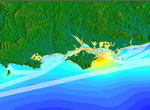
Anchorages represent specific areas where concentrated shipping activity has taken place and therefore have significant archaeological potential. For example, many naval ships were lost while anchoring on the Goodwin Sands off the east coast of Kent during the great storm of 1703. This is reflected in the substantial amount of archaeological material recorded in this area, including both shipwrecks and related debris such as anchors.
The evidence for anchorages was drawn from both historic records and modern hydrographic charts. The former were plotted as areas and the latter as buffered points.
Battles
Throughout history, many maritime battles occurred along the east coast and in the English Channel, an area of the important commercial shipping routes lying close to the European mainland. From the 15th century onwards there are many records of battles between English, Dutch, French, Spanish and Flemish fleets.
Until the development of firearms in the 16th century battleships fought at close quarters and vessels were often taken as prizes. As the use of ordnance became common, battles at sea became increasingly destructive and began to take place over much wider areas. Many vessels were partially destroyed or sunk during battles and sources document the jettison of material and the deliberate destruction of ships and their contents to prevent them falling into the hands of the enemy. Major engagements also often saw large numbers of vessels (up to a hundred vessels on each side) travelling in fleets to and from the naval battle sites. There is high potential, therefore, for the recovery of archaeological material at battle sites in the seas around the UK.
The locations of battle sites are rarely accurately recorded and discrepancies between sources are common. It was necessary, therefore, to evaluate individual sources to ascertain the most reliable data to characterise and map battle events.
Battle sites were plotted as points interpreted from the text of secondary sources (such as personal accounts) and, where possible, primary historical sources and charts. References to the direction of travel, line of attack and distance from the coast were used to locate points as accurately as possible. The sites of major battles were often plotted as a series of points, reflecting individual engagements. Where the distance of the battle from the shore could not be determined, points were plotted 15km offshore from the location described. Each point was also given a 15km buffer to compensate for any remaining uncertainty. The majority of battles mapped were located in the English Channel, with a high concentration in battle events recorded off the Downs in the Dover Straits.
Board of Trade Shipping Returns
The Board of Trade Shipping Returns survive from 1699 onwards and record the movement of ships to and from colonial ports. Each entry typically lists date, port, name of vessel and home port/port of registration, master’s name, type of vessel, burthen, where built and when, where and when registered, owner’s name, cargo details, place of departure and when and where any bond was given. Most documents are held at the PRO.
Casualties
Data relating to casualties records events that caused the loss or damage of a vessel but not necessarily its wrecking. These events can include vessels burnt, grounded, cast away, scuttled, prizes taken in battle, and wrecking, all of which may have an impact on the potential for wreckage or debris on the seabed. Numerous journeys recorded were related to descriptions of incidents at sea which did not necessarily lead to a wrecking event. Casualty events therefore had to be recorded to avoid breaking up related information.
The casualty data for England’s Shipping recorded pre-1730 events in the database to characterize the locations and manner of loss of the vessels, which was also plotted in the GIS. Data was extracted from secondary sources such as Larn's Shipwreck Index of the British Isles, Rodger's Safeguard of the Seas, and Hepper's British Warship Losses in the Age of Sail.
Many of the records were inferred from historic descriptions rather than based on archaeological evidence, and tended to be vague. The casualty locations mapped were given 5 kilometers buffers to reduce the uncertainty of the co-ordinates provided. The number of casualty events recorded in the database is currently too small to identify significant trends or relationships with other data.
Although casualty data can be obtained from the National Monument Record office, the recording of casualty data was necessary to maintain the relationships described between events. Further recording of the relationships between journeys and casualty events such as groundings and wrecking may in the future uncover trends in the data.
Customs records
Customs records date from the late 13th onwards and were created locally for central government. It was normal practice for the Exchequer to send out books for the customs officers of each port to enter the 'official' record of dues paid on imported or exported goods such as wool, cloth, lead and wine. As with Port Books, all movement of vessels carrying dutiable cargo into and out of a port should have been recorded in them, although this will rarely have been the case. Entries normally include:
- The name of the ship, master and merchants;
- The date of arrival or departure;
- Details of the cargo.
Approximately 8000 documents survive in the PRO and an unknown number in other record offices. This represents only a small percentage of those created. They are hand written in English or Latin.
From the mid-17th Century, records exist for the Board of Customs and Excise and its predecessors. These records are variable in type and content but include documents containing records of imports and exports from Britain and its colonies. The PRO is the main repository for these records. The total number of documents held there, which date from 1660 to 1990, is unknown.
In addition to national customs, a wide range of dues were imposed and recorded locally. Records of some of these dues are held in the PRO, whilst others are held in county record offices.
National Monuments Record
The National Monuments Record (NMR) is maintained by English Heritage and represents the largest publicly accessible archive dedicated to the historic environment. The archive is based at the National Monuments Record Centre in Swindon although many databases of information are held online.
The holdings consist of data on most known archaeological sites (both terrestrial and marine), modern and historic photography, almost total coverage of England in aerial photographs, a complete set of listed buildings descriptions, survey reports on specific buildings and archaeological sites, measured drawings, and a specialist reference library.
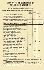
Port books
Port Books record local customs duties paid on overseas trade between 1565 and 1799. Smaller ports are usually incorporated within the Port Book of a larger head port. Recorded data includes:
- The name, tonnage and home port/port of departure of the arriving or departing ship;
- The destination or next port of call (not necessarily correct);
- Coastal movements;
- name of the merchants and whether they were foreign;
- Details of the cargo;
- The date of the payment of duty.
In many cases the date of arrival may not correspond exactly to the date of the payment of duty but it is reasonable to assume that payment would have been made within a short time after arrival. When a cargo was not subject to duty payments a certificate was issued stating as such. These are usually recorded in a separate list.
![]()
Theoretically, all movement of vessels carrying dutiable cargo into and out of a port should be recorded in the Port Books, although this will rarely have been the case due to smuggling, corruption and other evasion.
A total of approximately 20,000 Port Books have survived, although many are in a poor state of preservation and there are many gaps. They are hand-written and those compiled before 1600 tend to be written in Latin. There are a small number of similar documents for the period before 1565. Most Port Books are held in the PRO.
Ports
Areas of higher density shipping can have a disproportionately higher incidence of wrecks due to the inherent hazards related to multiple vessels operating in proximity to each other. Ports were therefore mapped to both provide a basis for designing the ship routes network and to characterise the increased shipping traffic expected within the approaches to ports that could indicate areas of increased archaeological potential.
The names of historical ports were provided by the National Monuments Record, many of which were accompanied by a history of maritime activity. Co-ordinates were generated using Ordnance Survey data (under licence).
Much of the information gathered during the project can be related to ports. They therefore provide a good basis for querying the data. For example, in many cases data relevant to journeys lacked specific information on the departure and destination points of those journeys and data within the port records was found to give a better representation of the density of marine traffic.
Royal Naval Masters' logs
Logs were kept for navigational purposes by the sailing masters of Royal Naval ships. Approximately 5000 exist for the period 1672-1871 and most are held at the PRO. They contain navigational data and information concerning discipline and other aspects of ship-board life.
Ship registers
Official registration of English shipping commenced in the 1660s although it was not made compulsory until 1786. Prior to 1786 the registers are unlikely to provide a comprehensive record of shipping although they are likely to have considerable value in providing data about the vessels identified in other sources. Most documents are held at the PRO and some earlier records survive amongst the State Papers.
Sites and Monuments Records and Historic Environment Registers
SMRs were established in local authorities across England from the 1960s to fulfil an increasingly important role in land-use planning. The number of SMRs increased, with the emergence of Urban Archaeological Databases, the creation of new unitary authorities following local government reorganisation and the development of SMRs by national parks, the National Trust and other land owners.
SMRs are a primary source of information on the local historic environment. They are fundamental to the conservation and management of the historic environment through the statutory planning system. They are also a valuable resource for education and research. SMRs hold databases and collections that cover archaeology and archaeological investigations from the prehistoric period to the 20th century. Many SMRs also hold information about listed buildings and other aspects of the historic environment for their areas. This holistic approach has seen the rise of the Historic Environment Register (HER) which allows a dynamic approach to heritage management, drawing on many data sets other than the point-type monument information.
The current non-statutory status of SMRs and HERs means that their funding and mode of operation varies greatly. For example, many SMRs do not hold data on sites or finds below the high water mark, except in cases where staff interest has prompted projects with a maritime focus.
Links to SMRs and HERs are often featured on county council and city council websites as part of planning information. An interactive map of local authority historic environment services can be accessed via the HELM website run by English Heritage.
Source appraisal
Research was carried out to first identify and then appraise as many appropriate primary and secondary sources as possible. The catalogues of Southampton City Library (SCL), the Public Record Office (PRO) and the Caird Library of the National Maritime Museum (NMM) were searched for relevant sources. A selection of sources was sampled for relevant data and assessed using the criteria set out below. Some data was recorded straight away so that the newly created database system could be tried using real data.
An annual report was produced at the end of the first year of the project to present the results of the initial source appraisal. The appraisal of sources has proven to be an ongoing process during the project. The types and formats of Historical records on maritime activities vary a great deal. During the gathering of data, new data is often identified which requires the database structure to be adapted to contain it.
The primary sources of information on shipping routes identified were Port Books, early Customer records, Board of Trade Shipping Returns, Royal Navy Masters’ Logs, Abstracts of Ships Journals and other Logs. Historic charts were also evaluated during the project as sources of information on battle site locations.
The Receiver of Wreck
Under the Merchant Shipping Act 1995 is it is legal requirement to report all items of wreck found in or on the shores of the sea or any tidal water to the Receiver of Wreck. Wreck is defined as:
Jetsam: goods cast overboard in order to lighten a vessel which is in danger of being sunk, not withstanding that afterwards it perishes.
Flotsam: goods lost from a ship which has sunk or otherwise perished which are recoverable by reason of their remaining afloat.
Lagan: goods cast overboard from a ship which afterwards perishes, buoyed so as to render them recoverable
Derelict: property, whether vessel or cargo, which has been abandoned and deserted at sea by those who were in charge of it without any hope of recovering it.
The Receiver of Wreck functions to ensure the rights of the finder and owner are upheld. This includes giving the legal owner the opportunity of recovering their property and ensuring that a salvage award is paid to the finder when due. It is based within the Maritime and Coastguard Agency (MCA) in Southampton, Hampshire although it deals with all reports of wreck from around the UK. Thus, the Receiver of Wreck can often provide a wide range of useful information concerning the nature of wreck material within a Study Area.
United Kingdom Hydrographic Office
The United Kingdom Hydrographic Office (UKHO) is a government Trading Fund and part of the Ministry of Defence. Their primary activity is the provision of navigational products and services to the Royal Navy and the merchant marine although they are also the premier provider of chart information for leisure purposes.
The UKHO Wrecks Information Service maintains a comprehensive database containing over 60,000 records of known wrecks, largely in UK territorial waters. Any member of the public, who wishes to obtain information on a particular wreck, or on any number of wrecks within a Study Area, can do so by contacting the UKHO wreck’s office. All wrecks of navigational significance are also charted on the largest scale Admiralty Charts.
Voyages
The project set out to design a network of shipping routes which could be used to visualise the density of shipping traffic moving from place to place. However, although a great deal of information is available from historic archives regarding shipping traffic, the descriptions of the routes themselves often remain vague. Generally, there is insufficient information to produce an exact representation of the paths that individual vessels actually took. It was possible, however, to provide an artificial model with which to characterise the trade relationships between ports, which can be used as a basis for plotting more exact information as and when it becomes available.
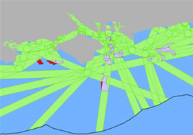
The route chosen by a vessel is dependent on a series of factors including; weather, currents, tides, politics, the reason for the voyage itself and the character of vessel technology at the time. The network of routes was drawn using a web of line segments which were located to take into account known hazards which had been historically recorded, such as shallows and obstructions on the seabed.
The routes network was created using the following attributes:
- Port locations;
- UK High Water and Low Water marks provided by Ordnance Survey;
- Modern 5 metre depth contour;
- 5 kilometre offset line from High Water contour;
- Modern and historic nautical charts;
- Modern and historic sailing directions.
Mapping was initially conducted using a combination of AutoCAD software for drawing and ArcView 8.3 GIS software for buffering, visualisation and querying. AutoCAD was used to produce a series of overlays containing shipping routes, modern high water and low water contours, and a modern 5m contour to allow for an incremental approach in the production of layers compatible with the GIS.
The artificial nature of the network meant that the further offshore the routes extended, the more likely they were to misrepresent the possible routes taken by ships. In order to limit this uncertainty the network was cut by a fifty kilometre buffer from the coast. The routes themselves were given a 5km buffer to avoid the erroneous impression that all vessels travelled from place to place along exactly the same line. In reality there may have been any number of possible routes followed by vessels between ports. A 5km buffer was chosen as there are many ports and routes around the UK that lie in close proximity and the use of a larger buffer may have led to difficulties in differentiating one route from another. The buffer also allowed the number of vessels recorded as travelling along particular routes to be graphically displayed while avoiding making inferences about the exact line each vessel took.
This approach, however, could only be applied to commercial traffic that tended to travel between ports and was recorded by port administration. Little evidence is available for naval voyages or small scale shipping from administrative records pre-1730. Naval records tend to describe movements between anchorages rather than ports and this meant that the movements of naval fleets and vessels were difficult to define. However, considering anchorages as quasi-ports would allow these routes to be mapped.
A further problem encountered in mapping the route network was the lack of documentary sources that recorded both the point of departure and the destination. In addition, many sources record only general locations, such as ‘Devon and Cornwall’ or ‘the South Coast’, and not the specific ports. In order to map a complete route, both the origin and destination must be identified as a specific geo-referenced point. It was thus necessary to classify the records within the database as complete or incomplete routes, so that only the complete routes would be carried through to the GIS for mapping.
Many sources record the journeys of fleets of ships but do not specify the number of vessels operating within these fleets. Therefore, it was also necessary to divide the data into fleet routes and vessel routes so the information could be represented and queried separately within the GIS and thus avoid distortion of the route network