Wessex Archaeology was commissioned in April 2003 to undertake the research project ‘Seabed Prehistory – gauging the effects of marine aggregate dredging’, funded by the Aggregate Levy Sustainability Fund (ALSF). The project demonstrated the scope for assessing prehistoric archaeology that has been covered by rising sea levels.
The sands and gravels targeted by marine aggregate dredging form part of Britain’s historic environment. They have the potential to contain evidence of our predecessors’ inhabitation of Britain, now thought to have begun up to 700,000 years ago. There have been successive changes in sea level since then, resulting in dramatic changes in the landscape, with much of the now submerged sands and gravels indicating early river systems and coastlines. At different periods, these river systems and their flood plains would have formed part of landscapes occupied by the early prehistoric inhabitants of Britain and north-west Europe. It is these remnant prehistoric landscapes within the current seabed that may contain archaeological deposits and evidence of where and how our predecessors lived.

Since the early 1990s the marine aggregate extraction permission process has required marine aggregate companies to prepare an Environmental Impact Statement (EIS) for each individual licence application. This statement addresses the potential impacts of dredging activity on all aspects of the marine environment, including the physical environment, fish and shellfish resources, fishing activity, navigation and the historic environment.
The archaeological component of an EIS assesses the form and character of predicted impacts on the historic environment. This involves evaluating now terrestrial prehistoric sediments (Palaeolithic and Mesolithic) which are now submerged and maritime archaeology such as shipwrecks and associated artefacts. The prehistoric archaeological potential of an area is characterised using survey data provided by the company undertaking an application and any literature or database sources that are relevant. On the basis of this assessment of archaeological potential, importance and predicted dredging impacts, appropriate mitigation is recommended.
Currently, the submerged prehistoric archaeology of a licence application area is assessed using a combination of sources, including models of north-west European prehistoric populations, models of palaeolandscapes and comparisons with evidence of Palaeolithic and Mesolithic activity from adjacent coastal areas. This material covers broad areas and is based on the extrapolation of a limited amount of archaeological evidence, which creates constraints when assessing specific aggregate applications to exploit relatively small areas. As a result, the palaeolandscape reconstruction necessary to evaluating archaeological potential, in particular, relies on the survey material collected by the marine aggregate company.
The archaeological consultant will generally receive survey data from the marine aggregate company to inform their assessment. However, the survey work undertaken by the aggregate company for an extraction licence application is primarily aimed at assessing the aggregate resource, and the survey strategy and specifications are therefore not always suitable for gathering data specific to archaeology.
The Seabed Prehistory project aimed to address this by developing methodologies for assessing and evaluating prehistoric seabed deposits in the course of licence applications. This involved directed geophysical and geotechnical surveys, geoarchaeological and environmental analyses and the integration of all data sources to produce reconstructions of palaeogeographies and environments.
Background
During the early prehistoric period, between approx. 700,000 and 8,000 years ago, sea level varied greatly. As a result of climatic change and a cycle of cold and warm periods, sea level rose and fell as large amounts of water were alternatively locked away in and released from ice sheets. Consequently, during various times in the Late Quaternary sea level was much lower than today and during these periods the North Sea and the English Channel became land surfaces. At times, Britain was no longer an island but became a northern peninsula of continental Europe.
During these periods this landscape became habitable to human populations. Prehistoric river valleys, or palaeovalleys, still surviving in the seabed stratigraphy are remnants of these prehistoric land surfaces. At various times during the Palaeolithic (c. 700,000-12,000 years ago), and particularly during the Upper Palaeolithic (c. 30,000-12,000 years ago) and early Mesolithic period (c. 12,000-6,000 years ago), parts of both the English Channel and the North Sea were inhabited by people.
The landscape would often have been suited to hunter-gathering-fishing communities. The pollen and fossilised micro-organisms from sediments within the seabed stratigraphy can be analysed to produce reconstructions of that environment; creating a picture of the plants, habitat, animals and the resources available to humans. This, combined with the palaeogeography (the topography of the land surface), can provide the information needed to assess the likelihood that a particular area was lived in by prehistoric communities.There are also terrace-like deposits associated with these relict, prehistoric river valley systems. The largely gravel, terrace-like deposits contain older material reworked by the ancient rivers, moved from higher up their drainage systems and redeposited in new locations. This reworked material can contain older, Lower and Middle Palaeolithic archaeological material (c. 700,000 - 30,000 years ago), primarily stone tools such as handaxes which can survive the redeposition process.
There are still a number of key research questions that need to be answered. The cycle of sea level rise and fall has created ‘layers’ of land surfaces and river valleys that overlay and cut into each other. Dating the sequence of these land surfaces so that palaeogeographies can be linked to a particular point in the early prehistoric period is an important step. Questions of how material remains were affected by being submerged, and most probably exposed and re-submerged, still remain. Equally, the effect of the sea’s movement, of waves, storms and long-term marine processes, on archaeological deposits is only beginning to be understood.
However, inshore, submerged archaeological sites in the Baltic, Scandinavia, the western Solent and Tynemouth have already been investigated. Flint tools and the bones of prehistoric animals are often dredged up by fishermen and have been found in the seabed grab-samples taken for benthic (marine life) analysis by marine biologists working on behalf of aggregate companies. Plus, the potential for preservation of organic material, such as wooden spears, axe shafts, bone harpoons, fishing equipment, skins and even dwellings, is much more likely in submerged conditions. This is exactly the kind of material that is often missing from the terrestrial archaeological record.
The study of submerged prehistoric landscapes and associated archaeological deposits is still a young science. However, the field promises to provide a different and valuable source of information about prehistoric peoples - societies in the very distant past. It has the potential to expand our knowledge of those societies and inform terrestrial archaeology, possibly even to transform the currently prevalent, terrestrial perspective itself.
Methodology
The main aim of the Seabed Prehistory project is to better understand the extent and character of prehistoric seabed deposits. Submerged prehistoric deposits can be affected by the industrial extraction of sand and gravel aggregates from the seabed. While the procedures for applying for aggregate extraction licences seek to minimise the impact of industry on archaeologically sensitive deposits, gaps exist in the methods of gathering data for Environmental Impact Statements. The project looks to maximise the archaeological information gained from existing survey methods. This will hopefully lead to more effective ways of gleaning archaeological information from the seabed and a deeper understanding of its archaeological potential.
Data was gathered using methods currently in used in archaeology and marine industries, or using variations on these methods. The approach to the acquisition and interpretation of this data is outlined below.
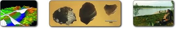
After identification of suitable study areas, geophysical surveys were carried out to map the seafloor and identify different horizons in the sediments beneath the seabed. The data obtained from these surveys was processed and reproduced as a 3D digital model. Geophysical survey results were used to identify areas on the seabed with archaeological potential. These areas were subjected to geotechnical surveys which involved the retrieval of seabed sediment samples. The samples were processed and geoarchaeological and environmental analyses were conducted. Analyses of these sediments provided information on the likely environment and ecology of the area in prehistory. From this information archaeologists have been able to reconstruct the now submerged landscapes.
One study area, the palaeo-Arun, was subjected to intensive survey which enabled archaeologist to produce a comprehensive reconstruction of the prehistoric environment.
A 3D computer animated visualisation was produced based on the palaeo-Arun reconstruction.
Gathering data
Information on the sea floor and submerged deposits of archaeological interest was gathered by offshore geophysical and geotechnical surveys. Sediments retrieved during geotechnical survey were subjected to geoarchaeological and environmental analyses to provide further information on the nature of the environment that would have existed during various stages in prehistory when the study areas were dry land. This allowed archaeologists to produce a reconstruction of the prehistoric environment.
Geophysical survey
Geophysical survey methods are widely used in archaeological investigations on land and in underwater survey. The surveys undertaken during the Seabed Prehistory project used multibeam and single beam echosounders and sidescan sonar to map the bathymetry and topography of the seabed. Seismic surveys were conducted using sub-bottom profilers to penetrate the seabed and provide information on the structure of sediments beneath the seafloor.
Echosounder survey
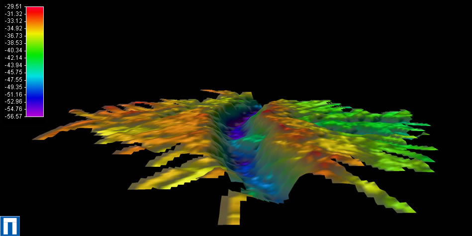
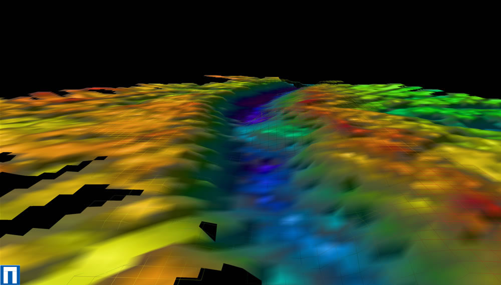
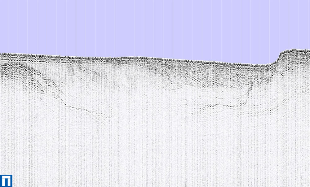
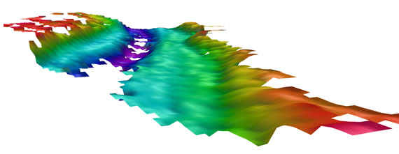
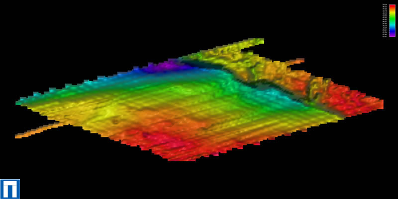 Echosounder systems measure bathymetry using acoustic energy. Echosounders measure the bathymetry by emitting a short acoustic pulse and then accurately measuring the time it takes for the pulse to be reflected back to the transducer. Then, assuming that the speed of sound in water is accurately known, this time can be converted into water depth. Multibeam systems operate in the same way as single beam echosounders but by using up to 100 or more beams at the same time so that large swathes of the seafloor can be surveyed very rapidly. Bathymetric surveys highlight topographical features on the seabed. This is highlighted in the picture on the left which illustrates bathymetric data from the Seabed Prehistory study area in the East English Channel. The processed single beam echosounder data was input into a software program named Fledermaus from which a surface was created. A digital elevation model (DEM) of the bathymetry within the survey area was produced.
Sidescan sonar survey
Sidescan uses a sonar device which may be towed from a surface vessel. The sonar device emits fan-shaped acoustic pulses down toward the seafloor across a wide angle perpendicular to the path of the sensor through the water, The intensity of the acoustic reflections from the seafloor of this fan-shaped beam is recorded in a series of cross-track slices, which when stitched together along the direction of motion, become an image of the sea bottom within the swath (coverage width) of the beam.
Seismic survey
Sub-bottom profiling systems are used to identify and characterize layers of sediment or rock under the seafloor. The technology involved is not dissimilar to the echosounder described above. A transducer emits an acoustic pulse vertically downwards towards the seafloor, and a receiver records the return of the pulse once it has been reflected off the seafloor. Parts of the acoustic pulse will penetrate the seafloor and be reflected off of the different sub-bottom layers. The time it takes the pulse to be reflected from the seafloor and different sub-bottom layers is then accurately measured. This data is then processed and can be used to find the thickness of the layers in the seafloor and their position. The data can also provide information on the composition of the sediments, as different sediment types will reflect sound in different ways
Geotechnical survey
Vibrocore survey
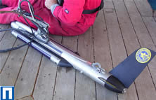
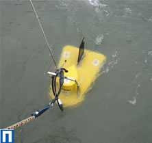
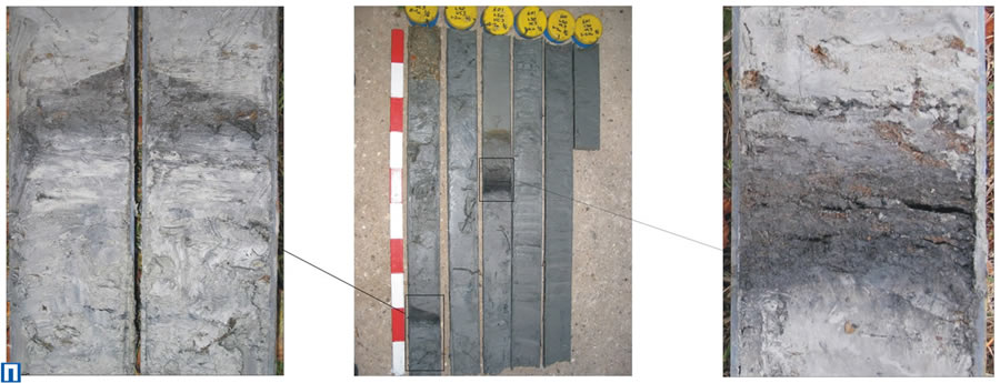
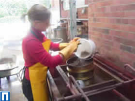
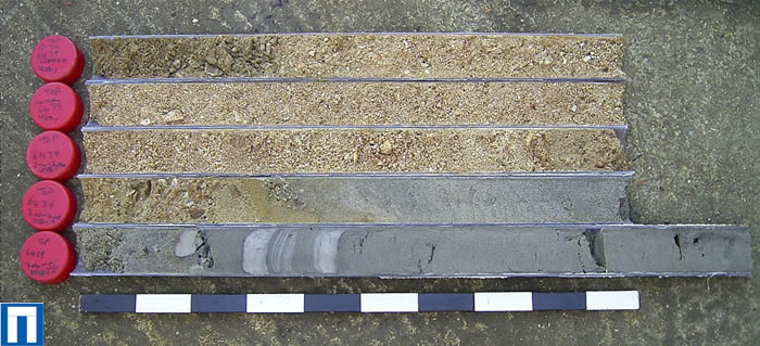
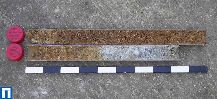
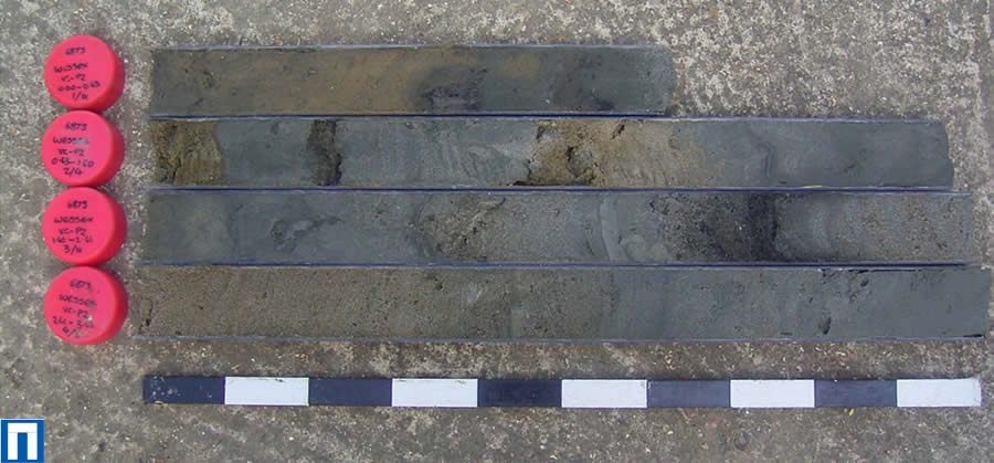
Vibrocore surveys involve acquiring cores of seabed sediments using what is essentially a vibrating steel tube which penetrates the seabed to a particular depth. During this project a 6m hydraulic vibrocorer was used to acquire the vibrocores. Each core was cut into 1m lengths, capped and labelled and taken back to Wessex Archaeologyheadquarters in Salisbury for comprehensive logging. In contrast to standard vibrocore survey methodology, the cores were not opened so that visual descriptions could be made on site; instead they were packed for a subsequent, more comprehensive logging process. The second cores from some locations were recovered using black vibrocore liners and kept separately in a darkened container to prevent exposure to light, so that they could later be used for Optically Stimulated Luminescence (OSL) dating.
Grab sampling survey
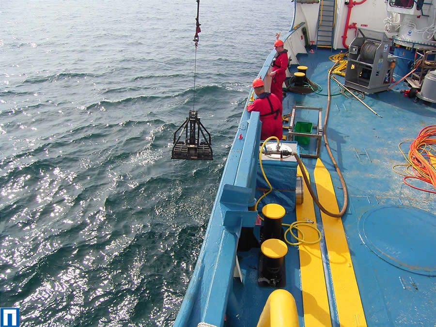 Seabed grab-sampling surveys are used by the aggregate industry solely as part of benthic (marine life) surveys undertaken in preparation for the marine ecological assessment element of an Environmental Impact Statement. This involves using a ‘grab’ to scoop a sample of sediment from the upper strata of the seafloor. As such, artefacts found in a grab sample are unlikely to be retrieved in archaeological deposits as any material from the upper layers of the seabed is likely to have been reworked from its original context. The semi-mobile, upper strata of the seabed that will be sampled during the survey are subject to marine sediment transportation processes.
Geoarchaeological analysis
The geoarchaeological analysis involves the examination and detailed description of the sediments recovered. The vibrocore log descriptions identify individual sedimentary units and record the structure, colour, texture and lithology of the sediments, describing any inclusions and the nature of the boundaries between the units. These details are used to make initial interpretations of each unit. The core log descriptions can highlight evidence of the manner in which the sediments were deposited. Features such as flood or tidal couplets, peat horizons, platy, gley clays and characteristic fluvial or tidal sequences of sedimentary units, provide evidence of the nature and relative speed of depositional processes and their environments, as well as providing material for environmental analysis such as pollen, diatoms and foraminifera.
Environmental analysis
The sediments are sampled and analysed for pollen, diatoms, foraminifera and other organisms which can provide information on the nature of the depositional environment. A combined programme of pollen, diatom and foraminifera assessment can provide evidence of the palaeovegetation and the nature of the environmental conditions prevalent at the time. It could identify, for example, the nature of a fluvial environment, potentially suggesting details such as that it was within the tidal reach with a constant but low freshwater discharge.
Pollen
The presence, variety and quantity of pollen species can identify the vegetation and nature of the depositional environment, (i.e. saltmarsh species would suggest a different environment to a woodland assemblage), and can also be characteristic of particular prehistoric periods.
Diatoms
Diatoms are unicellular microscopic algae found in marine and fresh water environments. The presence of diatoms within the sediment relates to the salinity of the depositional environment. Analysis of diatoms can provide evidence of the size of water bodies, their salinity and the warmth of the water.
Foraminifera
Foraminifera are mainly marine benthic or planktonic organisms consisting of either a single cell or a group of cells without differentiation of function. Analysis of foraminifera can identify where the sediment was within a salt marsh zone, illustrating, for example, how far from the sea that sediment was deposited.
Dating methods
Optically stimulated luminescence
Optically stimulated luminescence (OSL) dating or optical dating, developed from thermoluminescence (TL) methods, has been used to investigate a number of terrestrial sedimentary sequences over the last ten years. It has only recently been applied to the marine environment. The technique dates the deposition of sedimentary layers through the ‘luminescence signal’ of purified quartz or feldspar-dominated fractions. This essentially means that OSL dating analyses these minerals in the sediment and determines when they were last exposed to light.
Radiocarbon dating
Radiocarbon dating measures the rate of decay of Carbon-14, a radioactive isotope of carbon, found in organic matter. Carbon-14 breaks down at a known rate, so by measuring the quantity of the isotope in an organic sample, it can be determined when the isotope began to decay thus giving us an estimate of the relative age of the sample.
Reconstructing past landscapes
Data collected from geophysical and geotechnical surveys and that obtained from geoarchaeological and environmental analyses was synthesised to allow for the reconstruction of the palaeo-Arun prehistoric landscape, as described below. To find out more about the survey methods and analyses employed, click here.
Digital modelling
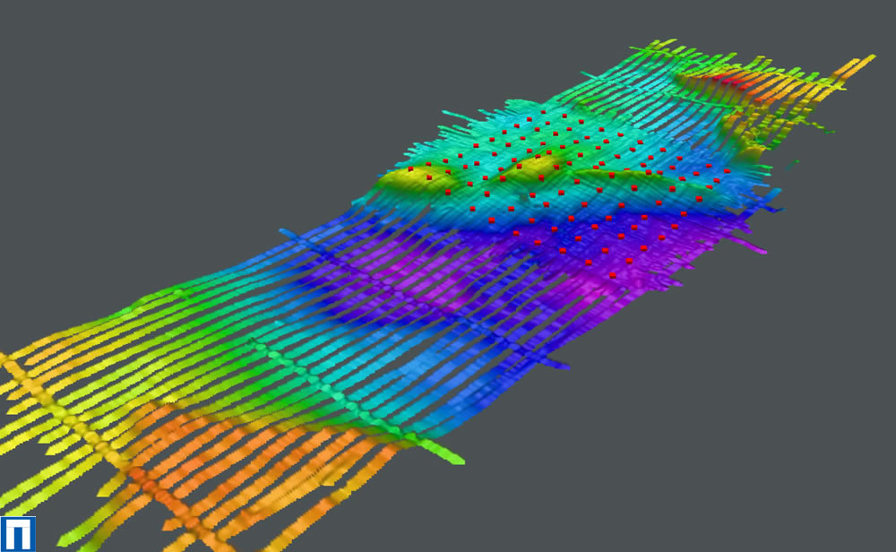
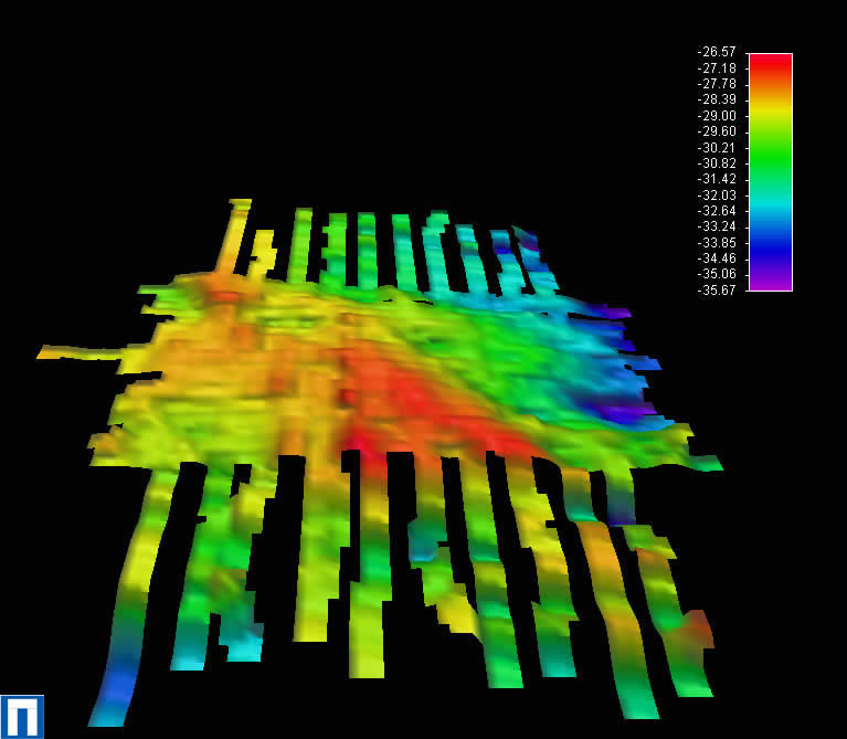
The seismic data from the geophysical surveys was used to create a 3D model of the submerged landscapes of the study areas, detailing the palaeovalleys and other topographical features. The seismic data was processed using a program called Coda Geosurvey. Coda Geosurvey allows an interpretation to be applied to a line of data by identifying and selecting boundaries between layers. After interpretation, the program can output the data in x ,y ,z format, essentially the data has an x-axis and y-axis to reflect its geographical position and a z-axis to illustrate its depth. The data collected during the 2003 – 2004 season was also processed with Geoframe and Promax software programs, these are more sophisticated programs more commonly used for interpreting more complex data sets from surveys for the oil and gas industries.
After processing and interpretation, data was then modelled using a program called Fledermaus. Fledermaus is a 3D-visualisation and analysis software package. This software can create 3D solid surfaces for any set of data containing points with an x, y and z value. These surfaces are made by gridding the data shading the surface with a user selected colour file so that the colours represent the relative heights over the surface. This 3D surface can then be explored and visualized. As these surfaces are best studied in 3D it can be difficult to get all the information they display onto a flat image, therefore Fledermaus allows profiles across these surfaces to be made to help show some of the vertical information.
Visualisation
The computerised reconstruction of the palaeo-Arun landscape was created by integrating data collected from geophysical and geotechnical survey to provide a basis for interrogation of the landscape during the early Mesolithic period.
The topographical data from geophysical surveys was exported as a digital elevation model (DEM). The DEM was then exported to a greyscale image which was imported into Vue, a computer imaging program. The height and horizontal scales of the terrain were then accordingly calibrated to model the geography of the area.
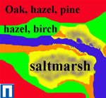
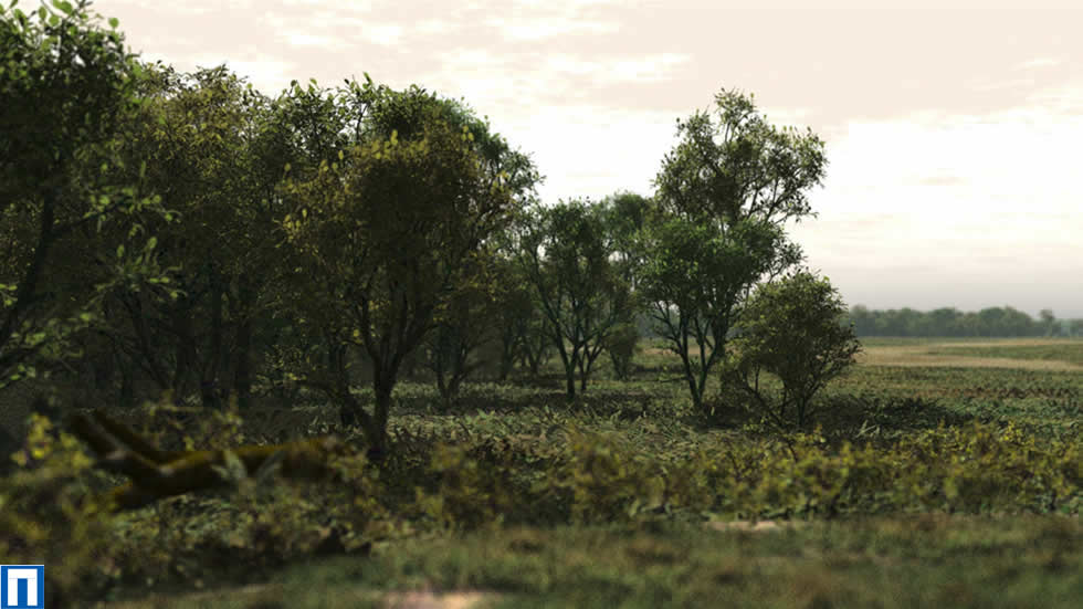
In order to add the vegetation, the landscape was divided into five ecozones. These were broadly decided upon using height and hydrology and the information on the potential ecology derived from environmental data. It was predicted that the upper drier areas (shown in red) supported a mixed hazel, oak, and pine woodland. A marshland/saltmarsh habitat was ascribed to the lower area (shown in blue-yellow), and fringing this (shown in green) was a mixed hazel, birch, willow and aspen woodland. The landscape was extended to incorporate an area of 3km by 3km. This was done to take in the peripheral views seen by the camera.
Composite photographs of real-world ground textures, sand, woodland floors, grasses etc. were used to cover the terrain used for each ecozone. For each ecozone a separate terrain model was used so that vegetation and ground textures could be added more easily. Rather than adding individual trees they were added using a function in Vue that allows a landscape to be populated with varying proportions of individual species.
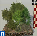
For scarcer species such as pine, willows, birches, and woodland shrubs, blackthorn, and dogwood, models from virtual libraries in a program called Greenworks XFrog were chosen. XFrog gives the user complete control over these virtual plants, allowing features, such as age and trunk thickness to be altered. Individual trees, shrubs, herbs and grasses were also modelled in Vue. Real photographs of bark, lichens, mosses, stems and leaves were used for the models.
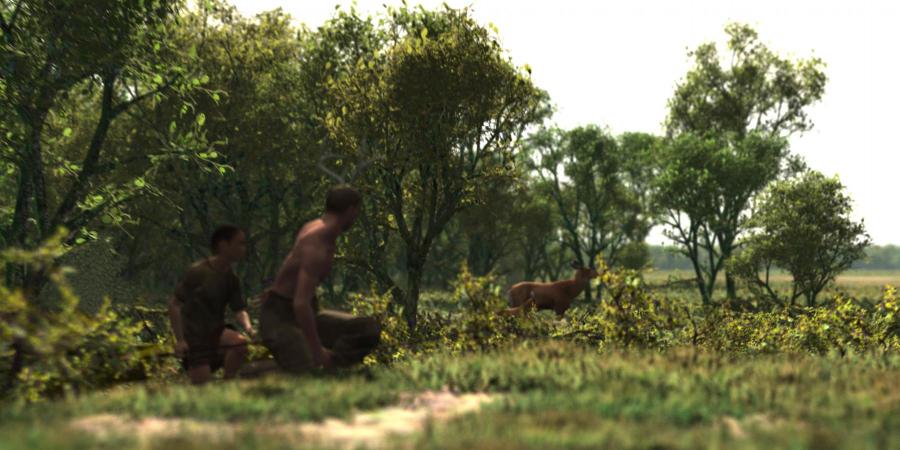
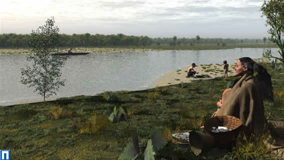
People and animals were added using Poser to suggest occupation of the area. Evidence from known Mesolithic archaeological sites was used as the basis for these elements. The people are shown fishing and gathering, activities known from the archaeological record. Similarly, the animals featured are well represented in the archaeological record for the Mesolithic period.
The data provided a spatial context to the landscape and the integration and forensic interrogation of that scientific and cultural data (i.e. palaeotopography, palaeoenvironmental, vegetation, archaeological and cultural) by archaeologists and palaeoenvironmentalists enabled the visualisation of the prehistoric landscape, vegetation, ecology and human action and activity.
Round one
The work undertaken in the 2003 - 2004 season was the first round of work on the Seabed Prehistory project. This initial phase was funded by the Aggregate Levy Sustainability Fund (ALSF) administered by the Mineral Industry Research Organisation (MIRO) under the Sustainable Land-Won and Marine Dredged Aggregate Minerals Programme (SAMP).

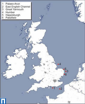
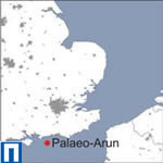
The work carried out in 2003 - 2004 focused on the palaeo-Arun, a submerged prehistoric continuation of the Arun river, located approximately 10km south of Littlehampton on the West Sussex coast. Extensive geophysical surveys were conducted, using bathymetric and seismic survey. Geotechnical surveys, involving the taking of vibrocore samples and grab samples were also undertaken at the study area. These samples were subjected to geoarchaeological and environmental analyses; results from which were integrated with the geophysical and geotechnical survey results to reconstruct the prehistoric environment of the study area.
This first round of the project sought to test the effectiveness of using the above methods for assessing the archaeological potential of the study area. While seismic geophysical surveys and vibrocore geotechnical surveys have been successfully used in archaeology before, grab sampling was virtually untested as an archaeological method.
Palaeo-Arun
Following consultation with representatives from the marine aggregate industry, preliminary prospecting took place in the area of the palaeo-Arun river within the Owers Bank region of the English Channel, c. 18km south of Littlehampton in Sussex. The prospecting stage of the survey involved collecting six lines of sub-bottom profiling data using a boomer seismic source.
The study area was chosen after studying the data from these survey lines and identifying a large palaeochannel. It was approximately 20m deep and 300m wide and was likely to have been a major geographic feature in the palaeolandsurface, implying a high archaeological potential. The palaeochannel feature was targeted for the study because these features are intimately related both to the presence of aggregate resources and to the potential presence and survival of archaeological material. These areas are very suitable for testing methodology because they represent challenging and varied geomorphology. They also have the best potential for the survival of organic material which is ideal for palaeoenvironmental reconstruction.
Survey work took place between 1-18 July 2003 and 27-29 September 2003. Twenty vibrocores, 108 seabed grab samples and 245km of seismic survey data were collected over a 3.5km by 1km area, but primarily in a central 1km² around the palaeochannel feature.
The wealth of data retrieved allowed archaeologists to reconstruct the palaeo-Arun prehistoric environment. As part of Round Two of the Seabed Prehistory project this reconstructed environment was recreated as a 3D computer animated visualisation.
Geophysical survey
From a preliminary review of this line of data it was possible to determine that the survey area covered a wide valley landform, approximately 2.5-3km wide, with the axis of the valley orientated NW-SE. The higher topography in the SE corner of the survey area was a bedrock feature. On the sloping valley side of this highland was an area of bright reflectors, which were interpreted as being peat horizons. The wide valley landform contained a sediment-filled palaeochannel at the centre of the survey area.
This palaeochannel was orientated E-W, approximately 200-300m wide and ranged from 14-18m deep. The sediments filling the channel were interpreted as being a fine grained unit composed of sand/silt and a coarse-grained gravel deposit which was situated on the southern bank of the palaeochannel.
The dimensions of the gravel deposit vary along the length of the channel. These gravels must have been deposited in a high-energy environment because a large amount of energy would be required to transport sedimentary particles of this size. The other fine-grained sand and silt deposits will have been laid down when the channel was in a low energy environment, which allowed these small sedimentary particles to drop out of suspension. The fine-grained sand and silts onlap the gravel deposit and were therefore deposited at a later stage.
The bedrock underlying the palaeochannel can be seen beneath the fine-grained channel in-fill and at a higher level on either side of the palaeochannel, indicating that the channel is incised in the bedrock. A small palaeochannel feature was observed on selected lines of seismic data only. This palaeochannel was cut into the bedrock underneath the main palaeochannel being studied.
Geotechnical survey
Vibrocore survey
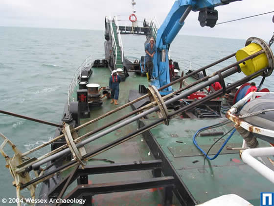 On 27-28 September 2003, a 6m hydraulic vibrocorer was used to acquire twenty vibrocores from ten locations within the study area. Each core was cut into 1m lengths, capped and labelled and taken back to WA for comprehensive logging. The second cores from each location were recovered using black vibrocore liners and kept separately in a darkened container to prevent exposure to light which would have rendered them unusable for Optically Stimulated Luminescence (OSL) dating.
Grab sampling survey
 On 27-29 September 2003, a total of 156 grabs were taken. From this, 108 samples, some of them combined, were collected. The initial visual examination on board the vessel identified four flints of potential anthropogenic origin. Very occasionally, a sample appeared to contain elements of peat or decaying organic remains within ‘humic’ clay. Where a large amount of this material was present within the sample, it was retained as a whole sample and processed accordingly in the laboratory.
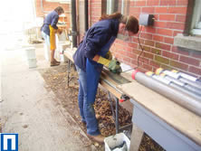
The laboratory processing of samples was conducted through a nest of sieves of mesh sizes 9.6mm (classed as 10mm for processing purposes), 4mm and 1mm. Slag, clinker and flint were all retrieved. Slag and clinker were both readily identifiable; the flints, however, being relatively small, were harder to categorically define. Non-diagnostic fired clay of unknown function and date also occurs. Apart from the presence of two bird bones, only fossilised bone was encountered.
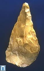
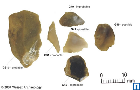
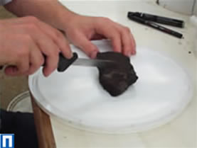
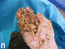
119 flints were retrieved from 50 of the 108 samples. Of those flints recovered, 22 came from the 10mm fraction, four of which were identified aboard the survey vessel, and 97 from the 4mm fraction. Of the 22 flints coming from the larger mesh twelve have elements indicative of human activity. Five of the identified flints have cortex visible, generally on one side of the flint (dorsal). Cortex is the outer surface of a piece of flint and so its presence on these five flakes indicates that these may be primary or secondary flakes from the initial stages of shaping the flint tool. None of these flints appear to be of a diagnostic type, though one has minor blade-like characteristics and another looks like a possible piercer.
Geoarchaeological analysis
The sedimentary deposits analysed, especially the palaeochannel fills, are substantial and appear to have accrued over a relatively short period of time given their size. The geoarchaeological core log descriptions highlight what appear to be either flood couplets or patterns of deposition produced by spring tides or tidal surges, in some palaeochannel fill deposits. It would potentially be possible to further clarify the rate of deposition if these features prove to deposition events produced by spring tides or tidal surges. These depositional events can be interpreted more precisely, by quantifying the accumulative seasonal tides, in a similar manner to counting tree rings, to produce a high resolution estimate of the rate of deposition.
There are two Late Devensian and early post-Devensian meltwater ‘pulses’ identified in the regional sea level curves, one at 14,500BP and one at 10,500-11,000BP, which may have been the source of this high volume sediment regime.
Environmental analysis
The initial assessment of the vibrocore samples from the palaeochannel sequences and the upper part of the wider palaeovalley form sequence all produced Boreal pollen assemblages. These contained a strong woodland component with fewer herbs, dominated by pine, oak, elm and hazel. They also indicated the presence of saline brackish water or marine conditions in the locale.
This relative uniformity of the vegetational assemblage suggested all the depositional environments were broadly contemporary. However, significant fluctuations in proportions of species in the various cores implied significant changes in vegetation and environment. For example, there was a discernible difference in the pollen and foraminifera assemblage of the lower part of one of the cores. The pollen assemblage in this core generally represented low and limited herbaceous diversity, dominated by arboreal and shrub elements, however, grasses were ‘extremely important’ in the lower part of the core. The foraminifera in particular suggested a range of environments from marine brackish near the base to salt marsh in the upper sediments.
As a result, fuller analysis of samples from cores from the wider valley edge deposits, palaeochannel and from the peat horizon in the wider valley floor deposits was undertaken.
Round Two
 The work undertaken in the 2004 - 2007 season was funded by Round Two of the Aggregate Levy Sustainability Fund (ALSF). Separate elements of the project were commissioned by the Mineral Industry Research Organisation (MIRO) and English Heritage (EH) respectively.
Elements of the 2004 - 2007 programme of work expanded upon the work carried out as part of Round One in 2003 -2004. MIRO commissioned the production of a 3D computer animated visualisation, a computer generated reconstruction of the Arun Mesolithic landscape based on the data gathered during the 2003 - 2004. EH commissioned an extended grab sampling survey in the palaeo-Arun area to expand upon the 2003 – 2004 survey. This was intended to provide a larger sample series for this area from to use in investigating the possibility of a relationship between struck flint and palaeogeographic features.
The majority of work carried out during the 2004 - 2007 season was concerned with trialling the project methodologies in new areas.
MIRO commissioned a new study areas in the Eastern English Channel dredging zone and the Humber which were subjected to geophysical survey and geotechnical survey including vibrocore and grab sampling.
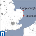
EH commissioned a new study area in Great Yarmouth which was subjected to geophysical survey and geotechnical vibrocore survey. In addition to this EH commissioned a trial of high resolution geophysical equipment to assess if beach deposits of known archaeological potential at Happisburgh and Pakefield could be traced offshore into the marine environment. This element was later expanded to include a geotechnical vibrocore survey.
Extended grab sampling
This extended grab sampling survey was undertaken to add to results already obtained in the grab sampling survey conducted in 2003-2004 in order to understand the relationship between struck flint and palaeogeographic features identified during the Round One project.
The fieldwork took place during May and June 2005. 400 ten litre benthic grab samples were collected from a survey area consisting of four 1km² blocks. 100 samples were taken at regular intervals of 100m. The samples were collected using a Hamon grab.
The samples were sieved on board through a 1mm mesh sieve and then transferred to a sample container. The samples were then transferred to the environmental department at Wessex Archaeology where they were wet sieved through 10mm, 4mm and 1mm sieves. The residues were scanned for archaeological material.
Results
668 flints were recovered. The assemblage is dominated by small chips and flakes with no definitely recognisable tool types. The flints were enigmatic due to the ambiguous nature of their means of production. In no instance was it absolutely certain that any piece was of human or anthropogenic manufacture.
Many of the samples contained large amounts of peat. In one sample a lump of mature oak charcoal was recovered. It is likely that this material is the product of deliberate burning or from fuel within a hearth. The peat itself contained large amounts of Phragmites sp. (common reed) stems. The deposit and the charcoal are currently being radiocarbon dated.
Other environmental remains were encountered including bone (amphibian, bird) molluscs (terrestrial, freshwater and marine taxa) moss, twigs all pointing towards wetland and terrestrial environments in the area.
Modern finds including slag and clinker were common within the samples. These are most likely the result of modern and industrial shipping activities.
Conclusions
The finds from the grab sampling have provided possible evidence of human occupation of the palaeo-Arun area. The charcoal recovered from a lump of peat is unlikely to have been produced by natural causes. Flints recovered from both this survey and the earlier Round One grab sampling surveys are also arguably of anthropogenic origin, although in many cases it is difficult to distinguish from flint produced by mechanical or natural processes.
These results will enable industry to adopt systematic archaeological procedures for the treatment of benthic grab samples obtained during the environmental impact assessment stage of marine aggregate licence applications.
East English Channel
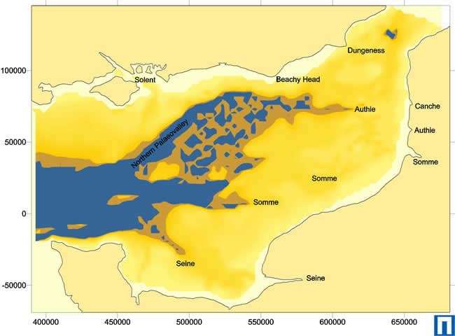
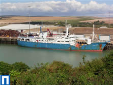
The Eastern English Channel was chosen as a study area due to its abundance of marine aggregates and lack of research with regard to prehistoric seabed deposits. A palaeovalley feature was chosen as a study area, situated between the licensed aggregate extraction areas 464 West and 464 East, both of which are operated by United Marine Aggregates. Palaeovalleys relating to offshore continuations of French and English rivers during periods of lowered sea level are known from the English Channel. Some of these palaeogeographic features are up to 50m in depth and several kilometres wide. Sediments within these channels, particularly those at depth can often be overlooked as they do not contain deposits economically exploited by the aggregate extraction industry. The survey was conducted aboard the MV Ocean Seeker between the 14th and 24th September 2005. The survey area was targeted for survey using geophysical (seismic and sidescan survey) and geotechnical (vibrocore and grab samples) methods.

Geophysical survey
Sidescan survey
The review of the sidescan sonar data showed a seabed comprising sandy gravel with trawl scars caused by fishing activity. During the data interpretation, the presence of irregular objects with shadows that could possibly be anthropogenic debris was noted.
Seismic survey
 The seismic data was acquired using a boomer sub-bottom profiler. A palaeovalley feature was identified in the seismic data. It extended throughout the study area, a distance of approximately four kilometres. The valley ranged in width from between 1.5 and 2 kilometres, with a depth of 40 – 45 metres. Evidence of several phases of cut and fill events were identified in the palaeovalley feature, some of which could not be traced in all the seismic profiles. This suggests that certain phases in the development of the valley are not fully represented. It is therefore difficult to postulate on the continuous development of the valley. An example of the boomer seismic data and a modelled surface are shown.
Geotechnical survey
Vibrocore survey
16 vibrocores were collected from eight sites identified from the geophysical data. Two cores were collected at each site. One core was taken for Optically Stimulated Luminescence (OSL) dating which was kept in a blackened sleeve. The other core was taken for geoarchaeological description and for retrieval of environmental and radiocarbon dating samples.
Grab sampling survey
 The grab samples were acquired using a Hamon grab. Each sample was approximately 8-10 litres in volume and retrieved from the upper 0.15 metres of the seabed. The samples were transferred to the environmental department at Wessex Archaeology and wet sieved through a nest of sieves in accordance with standard artefactual recovery procedures. None of the finds recovered were of prehistoric date.
Geoarchaeological analysis
The geoarchaeological analysis showed sediments relating to fluvial estuarine and marine processes. One important alluvial sequence featuring silts and clayey silts with interbedded fine sands was targeted for environmental sampling. One of the vibrocores featured gravels which had been oxidised. This is clear evidence that this deposit had been exposed to the air at some stage. This deposit was stratigraphically the oldest sediment (above bedrock) identified in this area and it is possible that it has been exposed on more than one occasion.The types of sediment units identified in the lower stratigraphy reflect high and low energy environments possibly relating to fluvial/estuarine sedimentation. Sub-units identified within these major sedimentary units revealed repeated layers of fine sands and silty clays which could indicate repeated, possibly seasonal, flooding. A brown sandy gravel with occasional mussel shell occurring in one of the vibrocores was considered to be indicative of a high energy environment with a possible marine contact inferred from the molluscs. It is possible that this may reflect rising sea levels represented by a transition between fluvial/estuarine conditions and marine conditions.
Environmental analysis
The pollen spectrum from the silts and clays in the analysed sample is dominated by pine and birch pollen. Although both of these species are often over represented in pollen spectra, the substantial numbers recorded here do suggest local growth and dominance on drier ground. The absence of any other tree and shrub reflects and environment likely to have existed either in the very early Holocene, Flandrian Chronozone I (c. 10,000 BP) or possibly the Windermere/Allerød late glacial interstadial (c. 13,500 BP). Foraminifera and ostracods were retrieved proving sub-littoral, estuarine and freshwater environments during the early Holocene period. The general trend shows estuarine and freshwater environments replaced by sub-littoral and shallow marine deposits. The most interesting ostracod assemblage shows silts and clays which appear to have been deposited in slow moving and still freshwater environments as demonstrated by the dominance of the taxa Ilyocypris monstrifica. This is the same deposit identified from the pollen data as being a freshwater fen possibly of very early Holocene or Windemere/Allerod date.
Dating
No stasis horizons (soils) were encountered in the vibrocores suitable for radiocarbon dating. Shells were abundant in some of the deposits. Due to the well preserved nature and probable rapid deposition of some of these deposits molluscan material from suitable deposits were chosen for radiocarbon dating. The latest episode of deposition is sub-littoral gravels and sands which have been dated to 8442±35 BP. This is a clear indication that the study area was being submerged at this time. Beneath this deposit samples from series of channel features thought to form part of a braided channel system are dated to 9811±35BP and 9663±35 BP. Five samples have been chosen for OSL dating and these have been sent to OSL Laboratory, Royal Holloway where they are currently being processed.
Conclusions
The area revealed a complex sedimentary sequence relating to fluvial activity during the Pleistocene period. Terrestrial, fluvial, freshwater, estuarine and shallow marine sediments were identified proving both the preservation of non-marine sediments and that landscapes with environments favourable for occupation existed in this area. The original formation of the main valley feature is difficult to date although they are probably pre-Anglian (c. 478,000 BP). OSL dating is currently being undertaken on some of the sediments in order to test this hypothesis. By counting back the major cut and fill events observed within the seismic data it is possible to generate nine possible rises and falls of sea level in the study area. This suggests that the earliest deposit might be of Cromerian date (c. 700,000BP). This is well beyond the range of radiocarbon and OSL dating. OSL dating of some of the sediments is hoped to generate a terminus ante quem (earlier than) date for some of the earlier deposits.
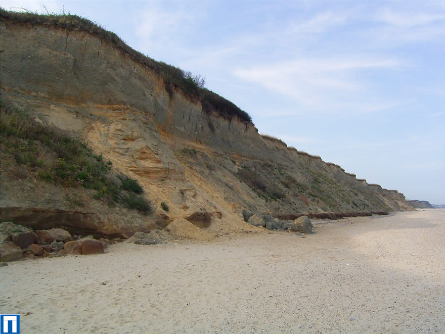
Happisburgh and Pakefield
The inspiration for the Happisburgh and Pakefield exposures project came from the unique opportunity to trace very early sediments of known archaeological potential offshore into the marine environment. The fine-grained sediments onshore are unique and have changed our understanding of the earliest occupation of Britain. Finds within these sediments have demonstrated that human occupation of northwest Europe may date to c. 700,000 BP rather than c. 500,000 BP as previously thought.
The survival of these deposits at the base of the cliffs at Happisburgh and Pakefield is unexpected considering their character and nature, and the series of geomorphological processes that have affected them. As these deposits reside at the base of the cliff line and on the foreshore there is a possibility for their survival offshore.
Demonstrating the survival of pre-Devensian fine-grained sediments offshore will radically alter the interpretations for very early prehistoric material in the seas around the UK, and therefore change the advice given to aggregate companies in the course of licence applications.
The method for this stage has involved geophysical survey, comprising bathymetric, seismic and sidescan surveys of areas off the coast of Happisburgh and Pakefield. Based on preliminary interpretations of the geophysical data, a further variation to the project was developed. This involved a geotechnical (vibrocore) survey at three locations identified from the geophysical data at the Pakefield site.
Geophysical survey
At Pakefield, the cliff exposure sediments comprise units of Cromer Forest-bed Formation overlying Wroxham Crag Formation sediments. The Cromer Forest-bed Formation cannot be traced offshore based on the data from the geophysical survey, though sediments interpreted as being part of the Wroxham Crag Formation were identified. It is possible that the Cromer Forest-bed Formation is preserved between the foreshore and the western limit of the study area. Offshore, it is considered that any sediments of the Cromer Forest-bed Formation that were deposited have been removed during either the Anglian glaciation or subsequent marine transgressions and regressions.
At Happisburgh, the survey was carried out further from the coast in deeper water to that of Pakefield due to the presence of beach groynes that posed a risk to the equipment. Only sediments interpreted as older than those identified in the cliff exposures and on the foreshore were identified on the geophysical data. However, it is possible that younger sediments relating to the Cromer Forest-bed Formation observed on the foreshore and related early Middle Pleistocene sediments may be preserved closer to the shoreline.
Geotechnical survey
A total of five vibrocores were acquired from three locations identified from the geophysical data at the Pakefield site. The purpose of these cores was to confirm and add detailed information on the stratigraphy observed from seismic survey and to provide environmental samples. At two of the three site locations, cores were specifically taken for Optically Stimulated Luminescence (OSL) dating.
Geoarchaeological analysis
 Vibrocore analyses enhanced the geophysical data interpretation and enabled a better understanding of the sediments and sediment deposition environments. This enabled correlation between onshore and offshore sediments. Although sediments of the Cromer Forest-bed Formation no longer exist offshore, older sediments interpreted as the Wroxham Crag Formation were identified. It was within the upper part of the Wroxham Crag Formation that worked flint was found onshore. The survey at Pakefield successfully demonstrated that sediment units identified onshore can be traced offshore and that not all of these very early terrestrial sediments that are now in submerged areas have been removed by glacial processes and/or marine erosion.
Environmental analysis
Pollen, diatom, foraminifera and ostracod subsamples have been taken from two vibrocores. These samples are currently being assessed in order to provide environmental information, biostratigraphic correlation and possible dating evidence from the described sedimentary sequence.
Great Yarmouth
The Great Yarmouth study area was selected as one of the new areas in which to trial the Seabed Prehistory project methodologies as it represents an aggregate dredging area with a different geological setting, and as such different archaeological potential, to areas previously surveyed during the course of the project.

Previous work in this area has highlighted peat and clay deposits close to the seabed occurring as part of a fine-grained sediment unit closely associated with the aggregate deposits within dredging area 254. These sediments are considered to be infill deposits within the Yare Palaeovalley. The River Yare was cut prior to the most recent marine transgression and is known to have extended offshore during periods of lowered sea level. Gravel deposits within area 254 could possibly contain reworked archaeological material including flint tools. Five flint implements of Palaeolithic date are known to have been found along the coast near Great Yarmouth. These records (based on a SMR data search) relate to finds of single stone tools, none of which are specifically dated to the Lower or Middle Palaeolithic.
A geophysical survey was conducted in the south-western corner of dredging area 254 (currently licensed to United Marine Aggregates Limited), approximately 10km to the east of Great Yarmouth. Survey work was carried out between August and October 2005. Based on the geophysical data, a geotechnical (vibrocore) survey was conducted in July 2006.
Geophysical survey
The geophysical survey involved the acquisition of bathymetry, sidescan sonar and sub-bottom profiler seismic data.
The results of the geophysical survey indicated the presence of a mound feature, predominantly composed of coarse sediments with areas of onlapping fine-grained sediments. At present it is unknown whether this feature is a landform which existed prior to the area being submerged by rising sea levels or if it is a product of erosion caused by rising sea levels.
The deepest sediment unit observed in the seismic data has been interpreted as the Yarmouth Roads Formation; a sediment formation which dates from the Cromerian period (478,000 to 787,000 BP). Throughout the study area the Yarmouth Roads Formation is overlain by a unit distinguished on the seismic data as high acoustic amplitude with irregular and chaotic reflections which have been interpreted as coarse sands and gravels. This structure reflects a high energy depositional environment as a large amount of energy would be required to transport particles of this size.
Geotechnical survey
The vibrocores were targeted at specific deposits so that detailed geoarchaeological interpretation and environmental sampling could be carried out. Geoarchaeological and environmental analysis of those deposits is currently being conducted at Wessex Archaeology’s headquarters in Salisbury. This will enable firmer conclusions to be drawn on the chronological, environmental and archaeological importance of Marine Aggregate Deposits in the Southern North Sea.
Area 240
Between 2008 and 2011 Wessex Archaeology conducted a detailed and far reaching study in aggregate licence Area 240, which is situated approximately 11 km east of Great Yarmouth in Norfolk. The project, entitled Seabed Prehistory: Site Evaluation Techniques (Area 240), built on the work of Wessex Archaeology’s Seabed Prehistory project.

The Area 240 project, which was funded by the Aggregate Levy Sustainability Fund (ALSF) through English Heritage, was initiated in response to the discovery in February 2008 of 88 flint tools and associated faunal remains amongst aggregate from dredging licence Area 240. Initial assessment of the flint tools indicated that they were Lower or Middle Palaeolithic. These finds represent one of the most significant discoveries of Palaeolithic material from the North Sea as the quality and quantity of the artefacts suggests that a number of them had lain undisturbed since their deposition.
Prior to this discovery, it was generally thought that deposits of this date had been destroyed or disturbed by glaciation and subsequent sea level rise. The discoveries from Area 240 suggest that in certain areas at least, some of this earlier material still survives under the sea.
This project fully investigated Area 240 in order to test, develop and refine techniques for exploring our submerged prehistory. By employing these techniques in the future we can hope to locate, explore and protect further sites of Palaeolithic significance in our waters.
To find out more why not purchase the publication here.
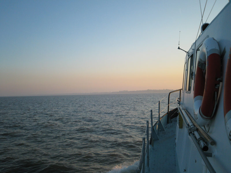
Humber
The Humber area has been chosen as one of the new study areas in which to trial the Seabed Prehistory project methodologies in the 2004 – 2007 season. A survey area has been chosen adjacent to licensed dredging areas.
The survey methodology from the Round One survey will be applied including seismic survey, vibrocoring and grab sampling. Geophysical survey data has been collected and is currently being processed. This part of the project is due to be completed in March 2007 which will include an interpreted suite of geophysical and geotechnical data.
Results
One of the principal aims of the Seabed Prehistory project was to develop methods and techniques for gathering archaeological data from the seabed. This involved developing existing survey methodologies already in use in various marine industries. One the main results of the project was in assessing the effectiveness of these survey techniques for archaeological data gathering.
The various surveys carried out during the course of the project produced a wealth of data which allowed archaeologists to begin to paint a picture of the prehistoric landscapes of the study areas. One study area in particular, the palaeo-Arun was subjected to extensive surveys and yielded sufficient data to produce a comprehensive reconstruction of the now submerged prehistoric river valley.
The palaeo-Arun was also modelled digitally. Geophysical surveys conducted in the study area resulted in the production of a 3D model of the topography of the now submerged landscape. This 3D model, integrated with data from the environmental reconstruction mentioned above, formed the basis for the production of a 3D computer animated visualisation of the palaeo-Arun in prehistory.
Assessment of methodology
One of the main aims of the Seabed Prehistory project has been to develop survey methods currently used in the various marine industries to assess their potential for gathering archaeological data from the seabed. The various methods are assessed below.
Bathymetric survey
Bathymetric survey, which maps seabed topography, is not an appropriate tool for assessing, identifying or studying submerged prehistoric landsurfaces and their associated archaeological deposits. It provides models of the modern horizon rather than any evidence of relict palaeogeographies or buried stratigraphy.
Seismic survey
Shallow seismic survey can provide a sufficient understanding of the subsurface geological structure as to allow features such as palaeochannels to be interpreted and modelled in 3D if the correct seismic source is used. Seismic surveys can help archaeologists to understand the palaeogeography of an area and can be used to guide further work such as vibrocore surveys. However the seismic data must be collected at a line spacing appropriate for delineating features of interest.
Geotechnical survey
Vibrocore survey
Archaeological input into the vibrocore survey locations is considered central to the success of environmental reconstruction and the development of palaeogeographic models.
Grab sampling survey
Grab sampling survey methodology can be applied for archaeological purposes. The process has successfully retrieved artefacts from the upper layers of the seabed. Consequently, it will also be an effective tool for establishing negative results and determining an absence of near-surface or eroding archaeological deposits, which would be both significant and fragile, and particularly at further risk from the impacts of dredging.
The trialled grab-sampling method could be easily implemented and is complimentary to the benthic (marine ecological) survey already undertaken as part of the Environmental Statement process. It has proven to be cost effective method of undertaking empirical evaluation for archaeological assessment.
Geoarchaeological analysis
Geoarchaeological core logging and descriptions were shown to provide significant additional information to geological logs and photographs. They provide sedimentary evidence of the depositional processes involved, as well as descriptions of the sediment types.
Geoarchaeological assessment in offshore circumstances through archaeological access to vibrocores is possible and productive. The value of environmental data to palaeogeographic reconstruction, providing dynamic environmental parameters through which to assess likely human presence, should not be underestimated.
The palaeo-Arun in prehistory
The survey work undertaken in the palaeo-Arun study area produced a wealth of data which has allowed archaeologists to model the prehistoric landscape which now lies submerged in the English Channel.
The evidence used to reconstruct the prehistoric landscape came primarily from seismic and environmental data. The surface terrain was modelled directly from the seismic data. The choice of strata to represent the past Arun landscape surface was based upon a peat layer that could be easily traced within the seismic data. Where such peat was not present the surface of the substantial deposits of gravel that underlay the most recent marine sediments were used.
While sources of evidence for the vegetation came predominately from the pollen analysis, the topography of an area has a substantial bearing on the distribution of this vegetation. Reconstruction of the area’s ecology was therefore considerably influenced by evidence for the nature of both the terrain and hydrology.
In turn both river and sea will have had a substantial affect on past vegetation patterns. The degree of marine influence has a direct bearing on the expanse and nature of peat formation and the type of salt marsh environment. Similarly the extent of the river’s floodplain and degree of tidal influence will affect the vegetation and deposits at the river edge.
In terms of reconstructing these hydrological patterns the main sources of information come from foraminifera and diatoms as well as the sediments themselves. Complementary to this are also certain maritime indicator species to be seen within the pollen sequences.
Background
The phase of this landscape’s history spans a period of at most 3,000 years between 10,000-7,000 BP. However, the main source of evidence relates to a series of peat horizons dating from around 9,600 to 9,000 BP. For the purposes of the reconstruction this period was divided into three broad vegetational phases which are outlined below. The final phase, beginning around 9,100 BP, forms the basis for the 3D computer animated visualisation.
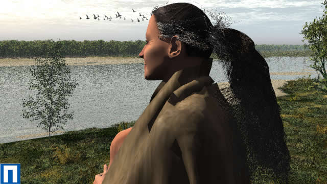
No direct evidence of fauna was recovered from the survey area and consequently such evidence for the people and animals occupying southern England at this time comes from that available other archaeological sites. It is probable that some changes within the fauna would have taken place during each phase. So that within Phase I and to a lesser extent in Phase II, large herbivores of more open conditions, such as reindeer and horse would have been more common.
Within Phase III we would expect to find a greater element of woodland fauna, so that wild boar, red deer, and roe deer would all be common within the woodland on the upper gravel terraces. Of the larger herbivores those present would have consisted of species often found in small groups or solitary individuals such as European elk, and the now extinct auroch. It is likely that such animals may have come down to the floodplain, and we might also expect to find brown bears within this region, while further up the channel away from the tidal reaches the european beaver might be found. There were probably few large predators within Britain at this time, wolves, fox, lynx and wild cat are all likely to have been present.
A great deal of bird life is also likely to have been present within the channel, with many common shore species present such as waders, ducks, herons, as well as gulls.
Phase I: 9629±50 BP
The channel would have been the main feature in the landscape. Seismic data only reveals the shape of the channel during its final phase, though during its earliest phase it is likely to have had several braided channels running within it; fed by spring and summer melt-water from retreating glaciers but dry in winter. This scenario is analogous with what is known of modern environments peripheral to modern retreating glaciers.
The river channel would have been fringed with various species of grasses, sedges, rushes and probably either marsh cinquefoil and/or silverweed. Areas of the channel edge which were under a greater maritime influence would have featured species such as sea plantain, sea pink, spurrey and various members of the goosefoot family.
The channel would have been set in a valley landscape with a species-rich short turf grassland, with an abundance of plants such as rock-rose, gentian, spring sandwort and low growing Cruciferae. Along with these species were more unusual species such as mountain avens and moonwort. Within the more rocky parts of this landscape we might also find various species of saxifrage.

A vibrocore VC3, taken some 1.5km from the main channel on the south-west edge of the survey area featured peat horizons and a high proportion of foraminifera species aassociated with tidal flats and/or lagoons, as well as mid-high salt marsh. This area would have featured a salt marsh environment in the later phases of the landscape. In this early phase however, peat formation was beginning to take place and fen marshland would have been found here and closer to the channel. Within the pools in the fen would have been white and yellow water lilies while surrounding these pools would be a species rich swathe of tall herbaceous vegetation. Comprising this would be species such as kingcup, globe flower, meadow sweet, common valerian, common bisort, monks hood and dock.
The wider landscape at this time consisted of sparse woodland largely consisting of individual isolated trees with dwarf shrubs in between. This shrubland would have consisted of grasses, crowberry, dwarf juniper, cowberry/bilberry and low growing shrub willows. Those trees which did exist were dominated by silver and downy birch on the upper gravels and on the drier sandier areas of the landscape as a whole. In addition occasional pines would also have been present on the driest reaches of the upper gravels.
Phase II: 9,300 BP
By this phase it is probable that a single gently meandering channel existed in the base of the main channel. It is unlikely that at this time the channel had any great width, probably only some 25 to 50m at most.

The lower lying areas at this time were becoming increasingly boggy with standing pools of water with water lilies and pondweeds surrounded by dense aquatic vegetation comprising sedges, grasses, bullrushes, bur reed and common reed. Many of these species would have also been present along stretches of the river edge, while grassland with sedges, butter cups and docks will have reached across the floodplain. Fringing the edge of the floodplain would be small stands of various species of willow.
As seen both within the channel and the lower lying areas this phase witnesses the increasing development of salt marsh. It is then probable that many species associated with such vegetation, such as cord-grasses, salt marsh grass and sea aster became increasingly prevalent as the phase progressed.
The overall impression of the landscape would have been one of denser tree cover than that of Phase I. The woodland would still have been relatively open aspect, with a dense heath/grassland understorey. The trees as such would be clustered in individual stands or copses with occasional isolated individuals in between. Pine woodland would have dominated though mostly confined to the upper reaches of the gravel and would have been interspersed with both downy and silver birch. It is probable that trees of aspen would still have still been present, perhaps also along with occasional whitebeam and sloe.
Phase III: 9,100 BP
This phase as already noted is the phase in which the reconstruction is set. While the extent and density of woodland is far greater than the previous two phases it should also be noted that in general the landscape is probably less species rich than the previous two phases. By this phase the channel would have been under considerable tidal influence. To this extent during high tides it is probable that the channel was flooded to its full width and height.
This is the final vegetation phase before the landscape was eventually lost to the sea. As such it should be remembered that we are dealing with an actively changing landscape in which the woodland was continually being pushed back by salt marsh development and the encroaching sea.
The salt marsh, by this phase, as well as being well established within the depression where the vibrocore VC3 was taken, it would also have colonised both sides of the lower reaches of the channel. The vegetation within the marsh would consist of cord-grasses, salt marsh grass, seagrass, sea plantain, sea lavender and sea aster. On the mudflats within and bordering the salt marsh would have emerged the distinctive green spikes of glasswort.

Upon the more sandier and gravel areas of the floodplain, plants of sea blites, marram grass, sea kale, sea bindweed sea-radish and sea-purslane would be present.
Wet, lower-lying reaches towards the salt marsh would not have supported the oaks and elm which would have existed in the woodlands on the upper reaches of the gravels. These areas would instead have featured relict vegetation stands from phase II, including occasional trees of birches, aspens, willow and other low-growing shrubs, such as sloe and dogwood. This vegetation would have come to edge of the salt marsh forming a dense swath along its edge with the occasional tree toppling in.
The main component of the vegetation during this phase is hazel which had become well and truly dominant. The abundance of hazel within various pollen diagrams at this date has been noted by a number of authors (cf. Godwin 1975). To produce such a proliferation of pollen, as noted by Rackham (2003), such hazel rather than being in the form of low growing, coppiced shrubs seen today would have formed instead substantial woodland. Whereas today hazel is recorded as growing to an average height of 6 metres, such individual trees would more probably have attained heights of between 10 and 15m. Within this dense hazel woodland the pollen spectra also hints at occasional oaks and elm, probably wych elm. Such vegetation would have occupied the drier upper reaches of the gravels and within this area it is probable that some pines survived into this phase.

Given the density of the canopy within these woodlands ground vegetation is likely to have been sparse. What we might expect to find are brambles, dog-mercury , bracken and occasional grasses, such as fescue. Such vegetation would have been densest within clearings where trees have died and toppled. Upon the stumps we might also expect to find ferns such as polypody.
References
Rackham, O. 2003, Ancient Woodland: Its History, Vegetation and Uses in England. Castlepoint Press, Kirkcudbrightshire.
Godwin, H. 1975, The History of the British Flora: a Factual Basis for Phytogeography, Cambridge.