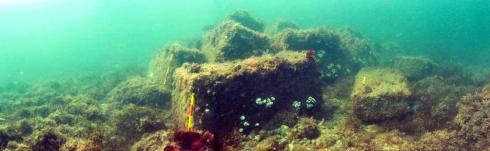
The true name of the Tal-Y-Bont wreck is unknown, but it was probably a 700-ton Genoese merchant ship lost in 1709 while carrying a cargo that included carrara marble blocks and paper. The wreck takes its name from the Tal-Y-Bont beach area in Cardigan Bay where it was found in 1978 by a group of local divers, later known as the "Cae Nest Group".
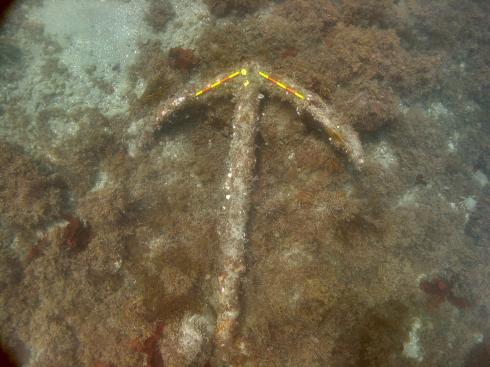
As well as a large mound of marble blocks, the site is made up of 26 iron guns, including 25 muzzle loading guns of various sizes and a probable breech loading iron swivel gun.
 The site was designated as a protected historic wreck site in 1979. Cadw now administers the wreck and the site licensee, monitors the site.
Wessex Archaeology's Diving Investigations
Wessex Archaeology was asked by Cadw to investigate the wreck as a "designated site assessment" as part of our work under the Protection of Wrecks Act (1973) in 2004.
Wessex Archaeology divers made a detailed photographic survey of the wreck site, prepared a georeferenced plan of the main exposed archaeological features of the site and made detailed measurements of the features on the site.
Wessex Archaeology obtained a large amount of photographic data of the wreck site and produced a georeferenced site plan that can now be used to monitor the condition of the site.
The site was designated as a protected historic wreck site in 1979. Cadw now administers the wreck and the site licensee, monitors the site.
Wessex Archaeology's Diving Investigations
Wessex Archaeology was asked by Cadw to investigate the wreck as a "designated site assessment" as part of our work under the Protection of Wrecks Act (1973) in 2004.
Wessex Archaeology divers made a detailed photographic survey of the wreck site, prepared a georeferenced plan of the main exposed archaeological features of the site and made detailed measurements of the features on the site.
Wessex Archaeology obtained a large amount of photographic data of the wreck site and produced a georeferenced site plan that can now be used to monitor the condition of the site.
 Based on existing knowledge of the wreck site, the exact circumstances of its loss cannot be established with any confidence based on the present remains. The vessel certainly ran aground in the bay, but it is not clear whether this was an accident caused by the crews' unfamiliarity with this coastline or done deliberately to prevent an already damaged vessel sinking in deeper open water.
A copy of the full report of Wessex Archaeology's investigations can be downloaded as a .pdf below.
Tal-Y-Bont, Designated Site Assessment, Full report
Map showing the protected wreck Tal-Y-Bont's location
Based on existing knowledge of the wreck site, the exact circumstances of its loss cannot be established with any confidence based on the present remains. The vessel certainly ran aground in the bay, but it is not clear whether this was an accident caused by the crews' unfamiliarity with this coastline or done deliberately to prevent an already damaged vessel sinking in deeper open water.
A copy of the full report of Wessex Archaeology's investigations can be downloaded as a .pdf below.
Tal-Y-Bont, Designated Site Assessment, Full report
Map showing the protected wreck Tal-Y-Bont's location