 A combination of documentary research and geophysical data have identified this shipwreck as that of the mid 19th century Swedish steamer Talis. The vessel sank with its cargo of coal after a collision with the ss Roman. In dive guides the wreck is usually called the "1906 wreck" after the year it sank and was later rediscovered.
The wreck site is situated 5.56nm SE of Beachy Head in East Sussex, just south of the Royal Sovereign Shoals, in 15.2m of water (CD). The dimensions of the wreck are approximately 65m x 12m.
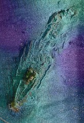
In August 2002 Wessex Archaeology surveyed the site using sidescan sonar and magnetometer. The sidescan data showed that the wreck was lying on an even keel and was largely buried. The amidship section of the vessel was broken up, which may be due to a salvage operation. The site was not dived during the 2002 fieldwork season due to adverse weather conditions.
 In June 2003 WA carried out further geophysical investigation of the site using multibeam sonar, and this corresponded with the previous year’s results. No dive survey was carried out in 2003 due to time constraints and adverse weather.
View geophysical images from both years' fieldwork, together with more information about the Talis and a link to find out the vessel specifications.
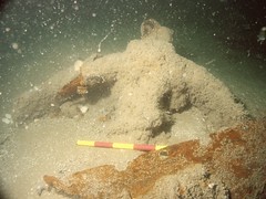
In the summer of 2005, the site was subject to both ROV (remotely operated vehicle) and diver survey. Examples of the video footage together with underwater photos, a site plan and information regarding the construction, vessel type, fittings and machinery of the Talis can all be viewed here.
[gmap markers=big red::50.6845,0.3812|zoom=8 |center=50.6845,0.3812 |width=100% |height=500px |control=Small |type=Map]