Broadcast 23 January 2005
Wessex Archaeology was commissioned by Videotext Communications Ltd to carry out archaeological recording and post-excavation analysis on an archaeological evaluation by Channel 4’s ‘Time Team’ at the site of a Roman fort at Drumlanrig Castle, Dumfries and Galloway (centred on NGR 285400 598900). The fort, whose ditches and street plan were identified from parch marks in 1984, covers some 1.8ha on a plateau overlooking the River Nith, with a possible ditched annexe on lower ground to the north-east.
The archaeological evaluation aimed to establish the date of the fort, which could have been used during the Flavian (AD 79-83) and/or Antonine (AD 140s-170s) campaigns. It also sought to provide further information about its layout and extent, and if possible about the size and composition of the military regiment stationed there. The results would inform the future management strategies for this part of the Drumlanrig estate. The work, which was carried out from 9-11th June 2004, included a geophysical survey of the site and twelve evaluation trenches.
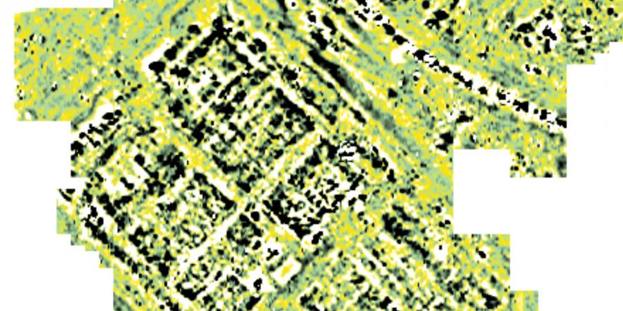
The geophysical surveys consisted of 1ha of resistance survey within the fort interior, and 3.4ha of detailed gradiometer survey which included the area of the annexe. It confirmed the ‘playing card’ shape of the fort’s bank and ditch defences, demonstrated a close relationship between the fort and the annexe and provided details of the street plan and the main blocks of building, with the locations of barrack blocks and the principia (headquarters building) being clearly identified. The results of the survey were used to identify suitable locations for the evaluation trenches.
A single 22m long trench was excavated across the innermost portion of the defences on the north-east side, and a further five small trenches were excavated at various locations across the front part of the fort (the praetentura), which comprised the north-western two-thirds of the fort. The remaining six trenches were excavated in the area of the principia). The defences trench revealed a wide V-shaped ditch and a turf rampart with stone foundations at the front and possibly to the rear. Within the fort, the trenches revealed beam slots, possible postholes, stone walls (some robbed) and floor surfaces associated with a number of buildings, including the principia, and metalled surfaces representing the edges of some of the streets. A stone-lined feature was tentatively interpreted as a water trough or cistern.
The size of the fort suggests that part of the auxiliary regiment may have been stationed in nearby fortlets, and there were hints that the troops included a cavalry component. All the finds recovered were Antonine in date, suggesting that the structures excavated were built and in use in the Antonine period. No evidence for an earlier, Flavian phase of occupation was identified, although the excavations undertaken were limited in scale and subject to significant time constraints. However, the excavations undertaken on the principia revealed evidence for two phases of activity, the lowest of which was not fully explored, and the possibility of an earlier phase of rampart construction cannot be ruled out. The abandonment of the fort appears to have been preceded by its deliberate destruction, involving the demolition and burning of structures, and the slighting of the rampart.