6.3285045576801, 5.6229654145332
Project summary
- Client: MOWAA and The British Museum
- Location: Benin City, Nigeria
- Sector: Research, Education
- Project duration: 2022 – 2025
Services provided
- Training and development
- Local engagement
- Geomatics/ geophysics
- Data capture
- Interpretation and reporting
The MOWAA Archaeology Project is taking place ahead of construction for the new MOWAA (Museum of West African Art) Cultural Campus in the historic Benin City. It aims to preserve a material record of the city’s transformation and improve understanding of Benin’s history. The project includes archaeological excavation, laboratory analysis, public engagement activities and knowledge exchange programmes. It is the largest archaeological research project to have taken place in Benin and the only excavation since the 1960s. This ground-breaking multi-year endeavour is a partnership between the Museum of West African Art (MOWAA), the British Museum and the Nigerian National Commission for Museums and Monuments (NCMM), and UK delivery partners, Cambridge Archaeological Unit and Wessex Archaeology.
Our role has been to support skills and knowledge development by training the archaeologists involved in the project, many of whom are early-career archaeologists and graduates from Nigerian universities established shortly after the country’s independence. We delivered support both on and off-site, as required by the MOWAA team, focusing on technical archaeological skills, primarily geophysics and geomatics. Our remit was to upskill the team and guide them in general survey principles, technical survey equipment and how to manage, process and understand the data.
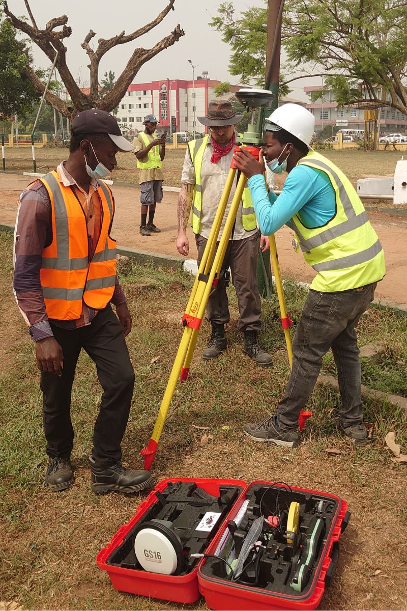
Above: MOWAA archaeologists set up a Total Station used in surveying
Supporting the next generation of local archaeologists through targeted on-site training
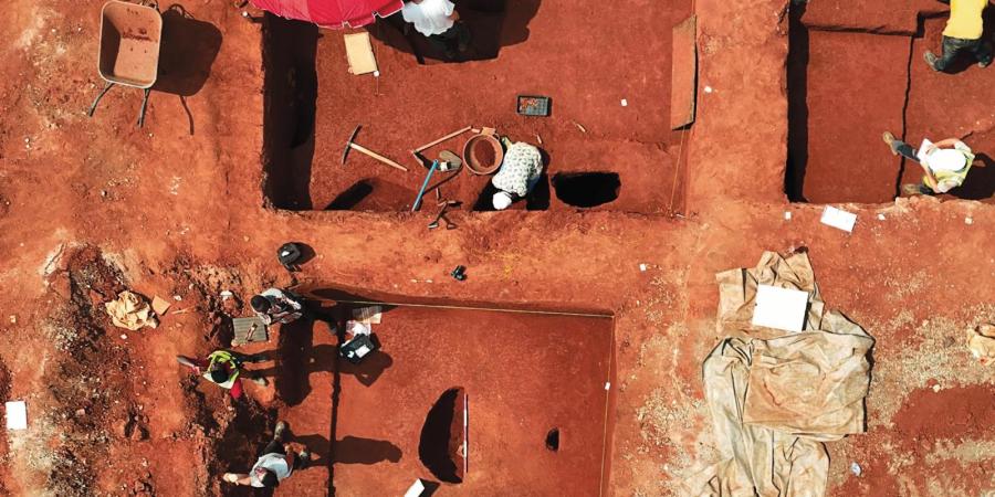
In February 2022, we sent three of our in-house experts to Benin City to support Phase One of the project, which included a GPR survey and a series of evaluation trenches at the museum site. Having been made aware of the gaps in knowledge, we began by familiarising the team with the total station and GPS equipment, enabling them to establish a local grid on site, locate this against the world grid and map out the location of new trenches. We demonstrated how to use a code list in the equipment to carry out archaeological recording, and how to import and export equipment data.
In addition, we acquainted the geophysicists from MOWAA with the GPR equipment and the data it collects. Soon, they were able to combine the GPS and GPR equipment to allow GPR data to be collected with an accurate location, reducing the reliance on manually established grids. Before returning to the UK, we also aided the excavation team, providing training on the use of the total station to record results.
In November 2022, two of our specialists returned to the site to support the excavation and geophysical surveys in Phase Two of the project. This phase built upon the previous season’s fieldwork, opening two excavation areas ahead of construction and performing further geophysical surveys in the northern section of the site.
Chris Breeden, our Spatial Data and Digital Innovation Manager, said: “The archaeologists from the MOWAA team have all been engaged and enthusiastic. It has been really interesting and rewarding to share knowledge and see them develop their new archaeological framework.”
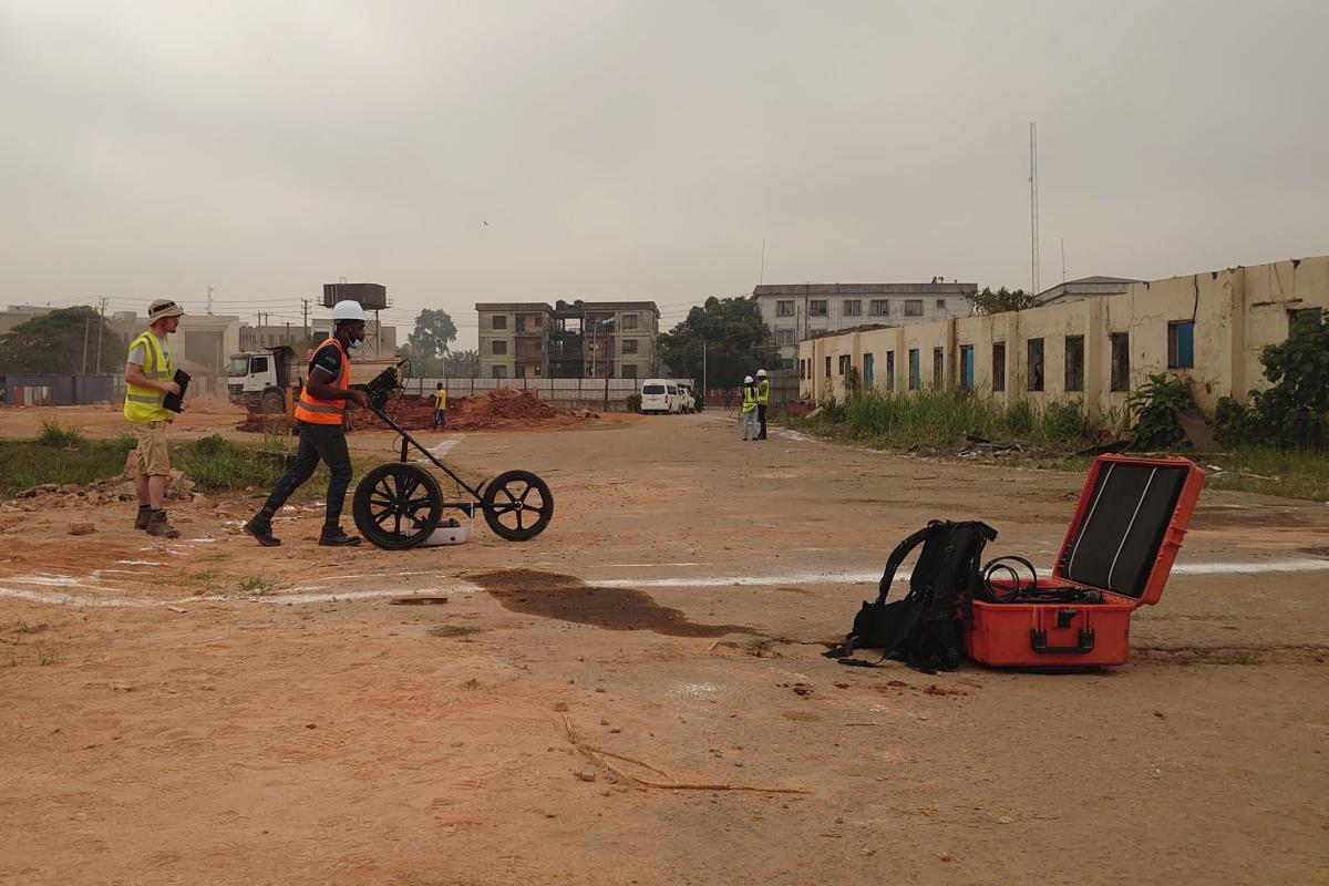
Above: Archaeologists from MOWAA undertake survey on the site
Providing specialist support beyond the field
With our work on-site complete, we now provide support remotely, offering specialist advice as needed. We also provide placement opportunities for MOWAA archaeologists with our teams based in the UK. These individuals work alongside our geomatics experts and observe their work first-hand.
We also wrote the report for the Phase One geophysical survey. This was one of the more challenging survey types to understand and required specialist hardware. The data interpretation from this phase was important for planning the works and understanding the wider archaeological context beyond these excavations.
Responding to methodological challenges
The main challenge faced by the experts in Benin was being able to provide accurately positioned data. Benin doesn’t have a GPS correction service so accuracy within three metres is usually all that can be achieved. To better this, we adapted our methodology to position the data on a local grid and then tied it to the world grid using a system called OPUS, provided by the National Oceanic and Atmospheric Administration (NOAA). This new method came in especially helpful when conducting geophysical surveys.
The original plan was to lay out survey grids by hand to record the locations and shoot them with the total station, but this is very time-consuming and requires a lot of post-processing to locate the data in the correct place. To avoid this, we adapted the relevant equipment using one of the points established through OPUS and set the kit up in a ‘base’ and ‘rover’ configuration. This meant that we did not need to set out the grids manually and could see immediately upon processing the data whether it was accurately located in the world.
The impact and outcomes
Our aim was to equip the MOWAA team with technical archaeological skills and knowledge and that was achieved. We are no longer needed on site, and the team is confident and capable working independently as they continue with the work on site. What’s more, the partnership has fostered lasting connections and established an international heritage community that continues to exchange ideas.